Bromsgrove geodata
Bromsgrove (England) is a populated place; located in United Kingdom in Europe/London (GMT+1) time zone. With population of 49,117 people, there are 238 cities with bigger population in this country. Compared to other cities in United Kingdom, 53.1% of cities are located further ↑North; 55.9% of cities are located further →East and 67.1% of cities have lower elevation than Bromsgrove. Note1


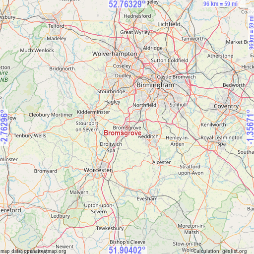
Bromsgrove GPS coordinates[2]
52° 20' 8.664" North, 2° 3' 35.388" West
| Map corner | latitude | longitude |
|---|---|---|
| Upper-left | 52.76329°, | -2.76296° |
| Center: | 52.33574°, | -2.05983° |
| Lower-right: | 51.90402°, | -1.35671° |
| Map W x H: | 95.5×95.5 km | = 59.3×59.3mi |
| max Lat: | 60.39635° ⇑53.1% North |
| Bromsgrove: | 52.33574° |
| min Lat: | ⇓46.9% South 34.60088° |
| min Long | Bromsgrove | max Long |
| -7.64133° | -2.05983° | 32.95536° |
| W 44.1%⇐ | ⇒55.9% E |
Elevation
Elevation of Bromsgrove is 90 m = 295 ft, and this is 17.1 m = 56 ft above average elevation for this country.
| Max E: |
515 m = 1690 ft | 32.9% |
| Bromsgrove | 90 m 295 ft | |
| Avg. | 72.9 m = 239 ft | |
Min E: |
-30 m = -98 ft | 67.1% |
See also: Bromsgrove elevation on elevation.city.
Geographical zone
Bromsgrove is located in North temperate zone (between Tropic of Cancer and the Arctic Circle). Distance of this North polar circle is 1582 km =983 mi to North.| Distance of | km | miles | from Bromsgrove |
|---|---|---|---|
| North Pole | 4187.9 | 2602.2 | to North |
| Arctic Circle | 1582 | 983 | to North |
| Tropic Cancer | 3213.3 | 1996.7 | to South |
| Equator | 5819.2 | 3615.9 | to South |


Nearby cities:
15 places around Bromsgrove: (largest is in red/bold)
• Alvechurch
6.7 km =4.2 mi,  74°
74°
• Astwood Bank
11.8 km =7.3 mi,  135°
135°
• Barnt Green
4.4 km =2.7 mi,  54°
54°
• Bartley Green
11.9 km =7.4 mi,  21°
21°
• Belbroughton
7.4 km =4.6 mi,  327°
327°
• Beoley
11.2 km =7 mi,  96°
96°
• Droitwich
9.8 km =6.1 mi,  218°
218°
• Hagley
11.1 km =6.9 mi,  335°
335°
• Hartlebury
11.8 km =7.3 mi,  268°
268°
• Hopwood
7.9 km =4.9 mi,  60°
60°
• Redditch
8.4 km =5.2 mi,  112°
112°
• Romsley
9.4 km =5.8 mi,  1°
1°
• Stoke Prior
4.2 km =2.6 mi,  199°
199°
• Stone
10.1 km =6.3 mi,  289°
289°
• Wychbold
6.3 km =3.9 mi, 216°
Sources, notices
• [Note1] Compared only with cities in United Kingdom existing in our database
• [Src1] Map data: © OpenStreetMap contributors (CC-BY-SA)
• [Src2] Other city data from geonames.org with taken over terms of usage.
• [Src3] Geographical zone / Annual Mean Temperature by Robert A. Rohde @ Wikipedia
