Rayleigh geodata
Rayleigh (England) is a populated place; located in United Kingdom in Europe/London (GMT+1) time zone. With population of 30,196 people, there are 404 cities with bigger population in this country. Compared to other cities in United Kingdom, 74.9% of cities are located further ↑North; 93.4% of cities are located further ←West and 54.1% of cities have lower elevation than Rayleigh. Note1


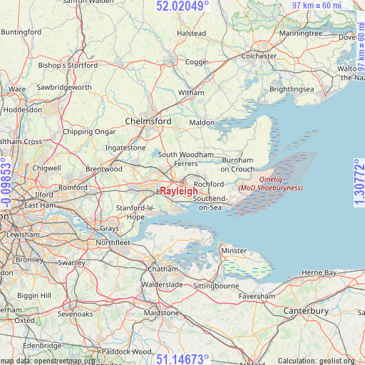
Rayleigh GPS coordinates[2]
51° 35' 8.556" North, 0° 36' 16.524" East
| Map corner | latitude | longitude |
|---|---|---|
| Upper-left | 52.02049°, | -0.09853° |
| Center: | 51.58571°, | 0.60459° |
| Lower-right: | 51.14673°, | 1.30772° |
| Map W x H: | 97.2×97.2 km | = 60.4×60.4mi |
| max Lat: | 60.39635° ⇑74.9% North |
| Rayleigh: | 51.58571° |
| min Lat: | ⇓25.1% South 34.60088° |
| min Long | Rayleigh | max Long |
| -7.64133° | 0.60459° | 32.95536° |
| W 93.4%⇐ | ⇒6.6% E |
Elevation
Elevation of Rayleigh is 67 m = 220 ft, and this is 5.9 m = 19 ft below average elevation for this country.
| Max E: |
515 m = 1690 ft | 45.9% |
| Avg. | 72.9 m = 239 ft | |
| Rayleigh | 67 m = 220 ft | |
Min E: |
-30 m = -98 ft | 54.1% |
See also: United Kingdom elevation on elevation.city.
Geographical zone
Rayleigh is located in North temperate zone (between Tropic of Cancer and the Arctic Circle). Distance of this North polar circle is 1665.4 km =1034.8 mi to North.| Distance of | km | miles | from Rayleigh |
|---|---|---|---|
| North Pole | 4271.3 | 2654.1 | to North |
| Arctic Circle | 1665.4 | 1034.8 | to North |
| Tropic Cancer | 3129.9 | 1944.8 | to South |
| Equator | 5735.8 | 3564.1 | to South |


Nearby cities:
15 places around Rayleigh: (largest is in red/bold)
• Basildon
10.3 km =6.4 mi,  259°
259°
• Canewdon
10.3 km =6.4 mi,  69°
69°
• Canvey Island
7.3 km =4.5 mi,  193°
193°
• Cold Norton
10.6 km =6.6 mi,  25°
25°
• East Hanningfield
11.2 km =7 mi,  343°
343°
• Hadleigh
3.7 km =2.3 mi,  174°
174°
• Leigh-on-Sea
5.7 km =3.5 mi,  147°
147°
• North Fambridge
8 km =5 mi,  37°
37°
• Pitsea
7.1 km =4.4 mi,  249°
249°
• Rochford
7.1 km =4.4 mi,  93°
93°
• South Benfleet
4.8 km =3 mi,  220°
220°
• Southchurch Village
10 km =6.2 mi,  120°
120°
• Southend-on-Sea
9.3 km =5.8 mi,  125°
125°
• Westcliff-on-Sea
7.6 km =4.7 mi, 127°
• Wickford
6.3 km =3.9 mi,  296°
296°
Sources, notices
• [Note1] Compared only with cities in United Kingdom existing in our database
• [Src1] Map data: © OpenStreetMap contributors (CC-BY-SA)
• [Src2] Other city data from geonames.org with taken over terms of usage.
• [Src3] Geographical zone / Annual Mean Temperature by Robert A. Rohde @ Wikipedia
