Westcliff-on-Sea geodata
Westcliff-on-Sea (England) is a section of populated place; located in United Kingdom in Europe/London (GMT+1) time zone. With population of 1,001 people, there are 3629 cities with bigger population in this country. Compared to other cities in United Kingdom, 76.3% of cities are located further ↑North; 94.1% of cities are located further ←West and 66.2% of cities have higher elevation than Westcliff-on-Sea. Note1


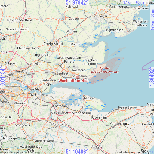
Westcliff-on-Sea GPS coordinates[2]
51° 32' 39.264" North, 0° 41' 30.444" East
| Map corner | latitude | longitude |
|---|---|---|
| Upper-left | 51.97942°, | -0.01134° |
| Center: | 51.54424°, | 0.69179° |
| Lower-right: | 51.10486°, | 1.39492° |
| Map W x H: | 97.2×97.2 km | = 60.4×60.4mi |
| max Lat: | 60.39635° ⇑76.3% North |
| Westcliff-on-Sea: | 51.54424° |
| min Lat: | ⇓23.7% South 34.60088° |
| min Long | Westcliff-on-Se | max Long |
| -7.64133° | 0.69179° | 32.95536° |
| W 94.1%⇐ | ⇒5.9% E |
Elevation
Elevation of Westcliff-on-Sea is 38 m = 125 ft, and this is 34.9 m = 115 ft below average elevation for this country.
| Max E: |
515 m = 1690 ft | 66.2% |
| Avg. | 72.9 m = 239 ft | |
| Westcliff-on-Sea | 38 m = 125 ft | |
Min E: |
-30 m = -98 ft | 33.8% |
See also: United Kingdom elevation on elevation.city.
Geographical zone
Westcliff-on-Sea is located in North temperate zone (between Tropic of Cancer and the Arctic Circle). Distance of this North polar circle is 1670 km =1037.7 mi to North.| Distance of | km | miles | from Westcliff-on-Sea |
|---|---|---|---|
| North Pole | 4275.9 | 2656.9 | to North |
| Arctic Circle | 1670 | 1037.7 | to North |
| Tropic Cancer | 3125.3 | 1942 | to South |
| Equator | 5731.2 | 3561.2 | to South |


Nearby cities:
15 places around Westcliff-on-Sea: (largest is in red/bold)
• Allhallows
9.2 km =5.7 mi,  204°
204°
• Canewdon
8.9 km =5.5 mi,  24°
24°
• Canvey Island
8.1 km =5 mi,  252°
252°
• Grain
9.9 km =6.2 mi,  172°
172°
• Great Wakering
7.8 km =4.8 mi,  83°
83°
• Hadleigh
5.7 km =3.5 mi,  279°
279°
• Leigh-on-Sea
3 km =1.9 mi,  267°
267°
• Lower Stoke
10.9 km =6.8 mi, 201°
• North Fambridge
11 km =6.8 mi,  353°
353°
• Rayleigh
7.6 km =4.7 mi,  307°
307°
• Rochford
4.3 km =2.7 mi,  13°
13°
• South Benfleet
9.2 km =5.7 mi, 276°
• Southchurch Village
2.6 km =1.6 mi,  99°
99°
• Southend-on-Sea
1.7 km =1.1 mi,  114°
114°
• Upper Stoke
12 km =7.5 mi,  205°
205°
Sources, notices
• [Note1] Compared only with cities in United Kingdom existing in our database
• [Src1] Map data: © OpenStreetMap contributors (CC-BY-SA)
• [Src2] Other city data from geonames.org with taken over terms of usage.
• [Src3] Geographical zone / Annual Mean Temperature by Robert A. Rohde @ Wikipedia
