Preston geodata
Preston (England) is a seat of a second-order administrative division; located in United Kingdom in Europe/London (GMT+0) time zone. With population of 313,332 people, there are 20 cities with bigger population in this country. Compared to other cities in United Kingdom, 75% of cities are located further ↓South; 68.9% of cities are located further →East and 69.2% of cities have higher elevation than Preston. Note1


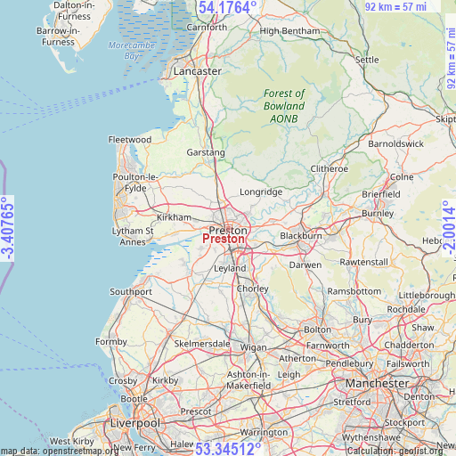
Preston GPS coordinates[2]
53° 45' 46.152" North, 2° 42' 16.272" West
| Map corner | latitude | longitude |
|---|---|---|
| Upper-left | 54.1764°, | -3.40765° |
| Center: | 53.76282°, | -2.70452° |
| Lower-right: | 53.34512°, | -2.0014° |
| Map W x H: | 92.4×92.4 km | = 57.4×57.4mi |
| max Lat: | 60.39635° ⇑25% North |
| Preston: | 53.76282° |
| min Lat: | ⇓75% South 34.60088° |
| min Long | Preston | max Long |
| -7.64133° | -2.70452° | 32.95536° |
| W 31.1%⇐ | ⇒68.9% E |
Elevation
Elevation of Preston is 34 m = 112 ft, and this is 38.9 m = 128 ft below average elevation for this country.
| Max E: |
515 m = 1690 ft | 69.2% |
| Avg. | 72.9 m = 239 ft | |
| Preston | 34 m = 112 ft | |
Min E: |
-30 m = -98 ft | 30.8% |
See also: Preston elevation on elevation.city.
Geographical zone
Preston is located in North temperate zone (between Tropic of Cancer and the Arctic Circle). Distance of this North polar circle is 1423.3 km =884.4 mi to North.| Distance of | km | miles | from Preston |
|---|---|---|---|
| North Pole | 4029.2 | 2503.6 | to North |
| Arctic Circle | 1423.3 | 884.4 | to North |
| Tropic Cancer | 3371.9 | 2095.2 | to South |
| Equator | 5977.9 | 3714.5 | to South |


Nearby cities:
15 places around Preston: (largest is in red/bold)
• Brinscall
12 km =7.5 mi,  133°
133°
• Clayton-le-Woods
7.7 km =4.8 mi,  161°
161°
• Croston
12.1 km =7.5 mi,  202°
202°
• Eccleston
13.4 km =8.3 mi,  184°
184°
• Euxton
10.5 km =6.5 mi,  169°
169°
• Freckleton
10.6 km =6.6 mi,  264°
264°
• Goosnargh
7 km =4.3 mi,  18°
18°
• Hoghton
8.3 km =5.2 mi,  112°
112°
• Kirkham
11.2 km =7 mi,  281°
281°
• Leyland
7.3 km =4.5 mi, 171°
• Longridge
10.3 km =6.4 mi,  41°
41°
• Ribchester
12.6 km =7.8 mi,  63°
63°
• Tarleton
12.3 km =7.6 mi,  221°
221°
• Warton
12.5 km =7.8 mi, 263°
• Woodplumpton
6.1 km =3.8 mi,  324°
324°
Sources, notices
• [Note1] Compared only with cities in United Kingdom existing in our database
• [Src1] Map data: © OpenStreetMap contributors (CC-BY-SA)
• [Src2] Other city data from geonames.org with taken over terms of usage.
• [Src3] Geographical zone / Annual Mean Temperature by Robert A. Rohde @ Wikipedia
