Pontefract geodata
Pontefract (England) is a populated place; located in United Kingdom in Europe/London (GMT+1) time zone. With population of 44,710 people, there are 266 cities with bigger population in this country. Compared to other cities in United Kingdom, 73.5% of cities are located further ↓South; 59.9% of cities are located further ←West and 55.3% of cities have lower elevation than Pontefract. Note1


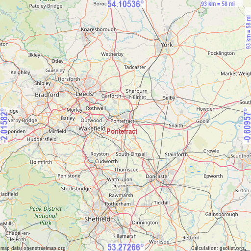
Pontefract GPS coordinates[2]
53° 41' 27.852" North, 1° 18' 45.684" West
| Map corner | latitude | longitude |
|---|---|---|
| Upper-left | 54.10536°, | -2.01582° |
| Center: | 53.69107°, | -1.31269° |
| Lower-right: | 53.27266°, | -0.60957° |
| Map W x H: | 92.6×92.6 km | = 57.5×57.5mi |
| max Lat: | 60.39635° ⇑26.5% North |
| Pontefract: | 53.69107° |
| min Lat: | ⇓73.5% South 34.60088° |
| min Long | Pontefract | max Long |
| -7.64133° | -1.31269° | 32.95536° |
| W 59.9%⇐ | ⇒40.1% E |
Elevation
Elevation of Pontefract is 69 m = 226 ft, and this is 3.9 m = 13 ft below average elevation for this country.
| Max E: |
515 m = 1690 ft | 44.7% |
| Avg. | 72.9 m = 239 ft | |
| Pontefract | 69 m = 226 ft | |
Min E: |
-30 m = -98 ft | 55.3% |
See also: Pontefract elevation on elevation.city.
Geographical zone
Pontefract is located in North temperate zone (between Tropic of Cancer and the Arctic Circle). Distance of this North polar circle is 1431.3 km =889.4 mi to North.| Distance of | km | miles | from Pontefract |
|---|---|---|---|
| North Pole | 4037.2 | 2508.6 | to North |
| Arctic Circle | 1431.3 | 889.4 | to North |
| Tropic Cancer | 3364 | 2090.3 | to South |
| Equator | 5969.9 | 3709.5 | to South |


Nearby cities:
15 places around Pontefract: (largest is in red/bold)
• Badsworth
7 km =4.3 mi,  173°
173°
• Byram
5 km =3.1 mi,  42°
42°
• Castleford
5.1 km =3.2 mi,  319°
319°
• Darrington
3.3 km =2.1 mi,  120°
120°
• Fairburn
6.2 km =3.9 mi,  17°
17°
• Featherstone
3.3 km =2.1 mi,  241°
241°
• Ferrybridge
3.1 km =1.9 mi,  45°
45°
• Fitzwilliam
7.7 km =4.8 mi,  213°
213°
• Knottingley
4.1 km =2.5 mi,  63°
63°
• Ledsham
8 km =5 mi,  1°
1°
• Ledston
7.1 km =4.4 mi,  343°
343°
• Low Ackworth
4.6 km =2.9 mi,  188°
188°
• Methley
7.3 km =4.5 mi,  305°
305°
• Normanton
6.9 km =4.3 mi,  278°
278°
• Sharlston
7 km =4.3 mi,  250°
250°
Sources, notices
• [Note1] Compared only with cities in United Kingdom existing in our database
• [Src1] Map data: © OpenStreetMap contributors (CC-BY-SA)
• [Src2] Other city data from geonames.org with taken over terms of usage.
• [Src3] Geographical zone / Annual Mean Temperature by Robert A. Rohde @ Wikipedia
