Castleford geodata
Castleford (England) is a populated place; located in United Kingdom in Europe/London (GMT+1) time zone. With population of 60,509 people, there are 180 cities with bigger population in this country. Compared to other cities in United Kingdom, 74.3% of cities are located further ↓South; 58.6% of cities are located further ←West and 85.8% of cities have higher elevation than Castleford. Note1


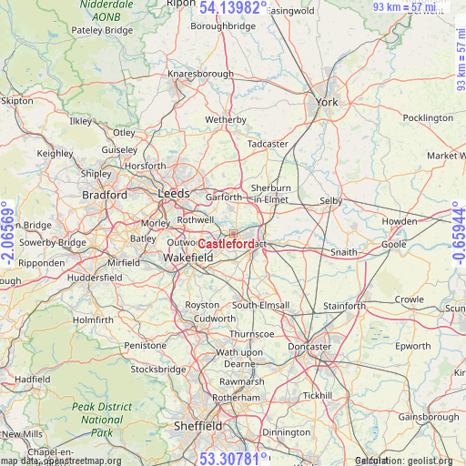
Castleford GPS coordinates[2]
53° 43' 33.132" North, 1° 21' 45.216" West
| Map corner | latitude | longitude |
|---|---|---|
| Upper-left | 54.13982°, | -2.06569° |
| Center: | 53.72587°, | -1.36256° |
| Lower-right: | 53.30781°, | -0.65944° |
| Map W x H: | 92.5×92.5 km | = 57.5×57.5mi |
| max Lat: | 60.39635° ⇑25.7% North |
| Castleford: | 53.72587° |
| min Lat: | ⇓74.3% South 34.60088° |
| min Long | Castleford | max Long |
| -7.64133° | -1.36256° | 32.95536° |
| W 58.6%⇐ | ⇒41.4% E |
Elevation
Elevation of Castleford is 15 m = 49 ft, and this is 57.9 m = 190 ft below average elevation for this country.
| Max E: |
515 m = 1690 ft | 85.8% |
| Avg. | 72.9 m = 239 ft | |
| Castleford | 15 m = 49 ft | |
Min E: |
-30 m = -98 ft | 14.2% |
See also: Castleford elevation on elevation.city.
Geographical zone
Castleford is located in North temperate zone (between Tropic of Cancer and the Arctic Circle). Distance of this North polar circle is 1427.4 km =886.9 mi to North.| Distance of | km | miles | from Castleford |
|---|---|---|---|
| North Pole | 4033.3 | 2506.2 | to North |
| Arctic Circle | 1427.4 | 886.9 | to North |
| Tropic Cancer | 3367.8 | 2092.7 | to South |
| Equator | 5973.8 | 3711.9 | to South |


Nearby cities:
15 places around Castleford: (largest is in red/bold)
• Byram
6.7 km =4.2 mi,  91°
91°
• Darrington
8.3 km =5.2 mi,  132°
132°
• Fairburn
5.6 km =3.5 mi,  68°
68°
• Featherstone
5.5 km =3.4 mi,  175°
175°
• Ferrybridge
5.7 km =3.5 mi,  107°
107°
• Garforth
7.4 km =4.6 mi,  350°
350°
• Kippax
4.6 km =2.9 mi, 353°
• Knottingley
7.3 km =4.5 mi, 106°
• Ledsham
5.5 km =3.4 mi,  40°
40°
• Ledston
3.2 km =2 mi,  22°
22°
• Methley
2.7 km =1.7 mi,  277°
277°
• Normanton
4.6 km =2.9 mi,  231°
231°
• Pontefract
5.1 km =3.2 mi,  139°
139°
• Sharlston
7.1 km =4.4 mi,  207°
207°
• Swillington
6 km =3.7 mi,  322°
322°
Sources, notices
• [Note1] Compared only with cities in United Kingdom existing in our database
• [Src1] Map data: © OpenStreetMap contributors (CC-BY-SA)
• [Src2] Other city data from geonames.org with taken over terms of usage.
• [Src3] Geographical zone / Annual Mean Temperature by Robert A. Rohde @ Wikipedia
