Polperro geodata
Polperro (England) is a populated place; located in United Kingdom in Europe/London (GMT+0) time zone. With population of 1,206 people, there are 3348 cities with bigger population in this country. Compared to other cities in United Kingdom, 98.9% of cities are located further ↑North; 93.5% of cities are located further →East and 66.2% of cities have higher elevation than Polperro. Note1


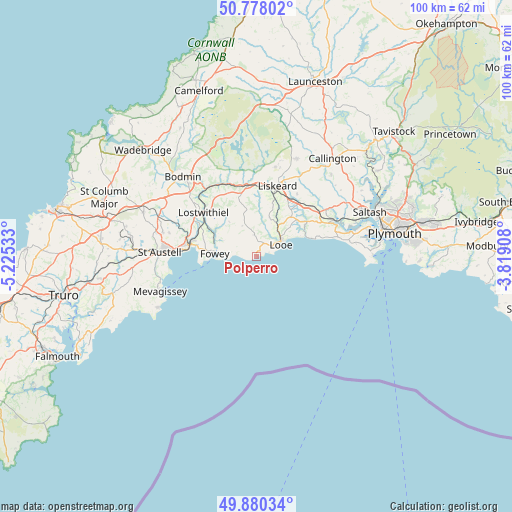
Polperro GPS coordinates[2]
50° 19' 52.68" North, 4° 31' 19.92" West
| Map corner | latitude | longitude |
|---|---|---|
| Upper-left | 50.77802°, | -5.22533° |
| Center: | 50.3313°, | -4.5222° |
| Lower-right: | 49.88034°, | -3.81908° |
| Map W x H: | 99.8×99.8 km | = 62×62mi |
| max Lat: | 60.39635° ⇑98.9% North |
| Polperro: | 50.3313° |
| min Lat: | ⇓1.1% South 34.60088° |
| min Long | Polperro | max Long |
| -7.64133° | -4.5222° | 32.95536° |
| W 6.5%⇐ | ⇒93.5% E |
Elevation
Elevation of Polperro is 38 m = 125 ft, and this is 34.9 m = 115 ft below average elevation for this country.
| Max E: |
515 m = 1690 ft | 66.2% |
| Avg. | 72.9 m = 239 ft | |
| Polperro | 38 m = 125 ft | |
Min E: |
-30 m = -98 ft | 33.8% |
See also: United Kingdom elevation on elevation.city.
Geographical zone
Polperro is located in North temperate zone (between Tropic of Cancer and the Arctic Circle). Distance of this North polar circle is 1804.9 km =1121.5 mi to North.| Distance of | km | miles | from Polperro |
|---|---|---|---|
| North Pole | 4410.7 | 2740.7 | to North |
| Arctic Circle | 1804.9 | 1121.5 | to North |
| Tropic Cancer | 2990.4 | 1858.1 | to South |
| Equator | 5596.3 | 3477.4 | to South |


Nearby cities:
15 places around Polperro: (largest is in red/bold)
• Bugle
20.5 km =12.7 mi,  290°
290°
• Dobwalls
14.1 km =8.8 mi,  1°
1°
• Duloe
6.4 km =4 mi,  25°
25°
• Fowey
8.3 km =5.2 mi,  273°
273°
• Landrake
19.3 km =12 mi,  58°
58°
• Liskeard
14.3 km =8.9 mi,  16°
16°
• Looe
5.7 km =3.5 mi, 58°
• Lostwithiel
13.5 km =8.4 mi,  309°
309°
• Menheniot
14.4 km =8.9 mi, 32°
• Mevagissey
20.2 km =12.6 mi,  251°
251°
• Par
13 km =8.1 mi,  279°
279°
• Pelynt
3.8 km =2.4 mi,  359°
359°
• Pillaton
20.5 km =12.7 mi,  50°
50°
• Polruan
7.8 km =4.8 mi, 266°
• St Austell
17.9 km =11.1 mi, 273°
Sources, notices
• [Note1] Compared only with cities in United Kingdom existing in our database
• [Src1] Map data: © OpenStreetMap contributors (CC-BY-SA)
• [Src2] Other city data from geonames.org with taken over terms of usage.
• [Src3] Geographical zone / Annual Mean Temperature by Robert A. Rohde @ Wikipedia
