Mevagissey geodata
Mevagissey (England) is a populated place; located in United Kingdom in Europe/London (GMT+1) time zone. With population of 2,117 people, there are 2553 cities with bigger population in this country. Compared to other cities in United Kingdom, 99.1% of cities are located further ↑North; 95.1% of cities are located further →East and 92.6% of cities have higher elevation than Mevagissey. Note1


Mevagissey GPS coordinates[2]
50° 16' 23.664" North, 4° 47' 29.976" West
| Map corner | latitude | longitude |
|---|---|---|
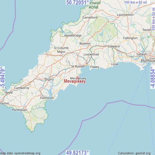
| Upper-left | 50.72051°, | -5.49479° |
| Center: | 50.27324°, | -4.79166° |
| Lower-right: | 49.82173°, | -4.08854° |
| Map W x H: | 99.9×99.9 km | = 62.1×62.1mi |
| max Lat: | 60.39635° ⇑99.1% North |
| Mevagissey: | 50.27324° |
| min Lat: | ⇓0.9% South 34.60088° |
| min Long | Mevagissey | max Long |
| -7.64133° | -4.79166° | 32.95536° |
| W 4.9%⇐ | ⇒95.1% E |
Elevation
Elevation of Mevagissey is 10 m = 33 ft, and this is 62.9 m = 206 ft below average elevation for this country.
| Max E: |
515 m = 1690 ft | 92.6% |
| Avg. | 72.9 m = 239 ft | |
| Mevagissey | 10 m = 33 ft | |
Min E: |
-30 m = -98 ft | 7.4% |
See also: United Kingdom elevation on elevation.city.
Geographical zone
Mevagissey is located in North temperate zone (between Tropic of Cancer and the Arctic Circle). Distance of this North polar circle is 1811.3 km =1125.5 mi to North.| Distance of | km | miles | from Mevagissey |
|---|---|---|---|
| North Pole | 4417.2 | 2744.7 | to North |
| Arctic Circle | 1811.3 | 1125.5 | to North |
| Tropic Cancer | 2983.9 | 1854.1 | to South |
| Equator | 5589.9 | 3473.4 | to South |


Nearby cities:
15 places around Mevagissey: (largest is in red/bold)
• Bugle
13.6 km =8.5 mi,  359°
359°
• Fowey
12.9 km =8 mi,  57°
57°
• Gerrans
17.1 km =10.6 mi,  232°
232°
• Gorran Haven
3.5 km =2.2 mi,  178°
178°
• Grampound
8.3 km =5.2 mi,  290°
290°
• Nanpean
12 km =7.5 mi,  332°
332°
• Par
10.7 km =6.6 mi,  36°
36°
• Polruan
12.8 km =8 mi, 62°
• Portscatho
17.1 km =10.6 mi, 229°
• Probus
11.7 km =7.3 mi,  280°
280°
• Roche
15.3 km =9.5 mi,  348°
348°
• Saint Dennis
13.9 km =8.6 mi, 332°
• Saint Stephen
11 km =6.8 mi,  315°
315°
• St Austell
7.8 km =4.8 mi,  9°
9°
• Tregoney
8.9 km =5.5 mi,  265°
265°
Sources, notices
• [Note1] Compared only with cities in United Kingdom existing in our database
• [Src1] Map data: © OpenStreetMap contributors (CC-BY-SA)
• [Src2] Other city data from geonames.org with taken over terms of usage.
• [Src3] Geographical zone / Annual Mean Temperature by Robert A. Rohde @ Wikipedia
