Penygroes geodata
Penygroes (Wales) is a populated place; located in United Kingdom in Europe/London (GMT+1) time zone. With population of 1,793 people, there are 2784 cities with bigger population in this country. Compared to other cities in United Kingdom, 61.4% of cities are located further ↓South; 91.4% of cities are located further →East and 76.5% of cities have lower elevation than Penygroes. Note1


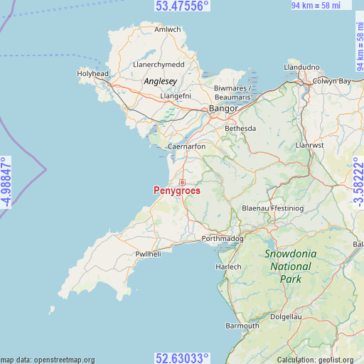
Penygroes GPS coordinates[2]
53° 3' 18.072" North, 4° 17' 7.26" West
| Map corner | latitude | longitude |
|---|---|---|
| Upper-left | 53.47556°, | -4.98847° |
| Center: | 53.05502°, | -4.28535° |
| Lower-right: | 52.63033°, | -3.58222° |
| Map W x H: | 94×94 km | = 58.4×58.4mi |
| max Lat: | 60.39635° ⇑38.6% North |
| Penygroes: | 53.05502° |
| min Lat: | ⇓61.4% South 34.60088° |
| min Long | Penygroes | max Long |
| -7.64133° | -4.28535° | 32.95536° |
| W 8.6%⇐ | ⇒91.4% E |
Elevation
Elevation of Penygroes is 110 m = 361 ft, and this is 37.1 m = 122 ft above average elevation for this country.
| Max E: |
515 m = 1690 ft | 23.5% |
| Penygroes | 110 m 361 ft | |
| Avg. | 72.9 m = 239 ft | |
Min E: |
-30 m = -98 ft | 76.5% |
See also: United Kingdom elevation on elevation.city.
Geographical zone
Penygroes is located in North temperate zone (between Tropic of Cancer and the Arctic Circle). Distance of this North polar circle is 1502 km =933.3 mi to North.| Distance of | km | miles | from Penygroes |
|---|---|---|---|
| North Pole | 4107.9 | 2552.5 | to North |
| Arctic Circle | 1502 | 933.3 | to North |
| Tropic Cancer | 3293.2 | 2046.3 | to South |
| Equator | 5899.2 | 3665.6 | to South |


Nearby cities:
15 places around Penygroes: (largest is in red/bold)
• Bontnewydd
6.9 km =4.3 mi,  9°
9°
• Caernarfon
9.6 km =6 mi, 6°
• Chwilog
15.3 km =9.5 mi,  191°
191°
• Criccieth
15.3 km =9.5 mi,  167°
167°
• Deiniolen
14.6 km =9.1 mi,  44°
44°
• Dwyran
12.7 km =7.9 mi,  348°
348°
• Gaerwen
18.5 km =11.5 mi,  2°
2°
• Groeslon
2.7 km =1.7 mi, 6°
• Llanberis
12.6 km =7.8 mi,  56°
56°
• Llanfairpwllgwyngyll
19.3 km =12 mi,  16°
16°
• Llanrug
11.9 km =7.4 mi,  30°
30°
• Llanwnda
5.2 km =3.2 mi, 5°
• Porthmadog
17.4 km =10.8 mi,  143°
143°
• Talysarn
1.9 km =1.2 mi,  94°
94°
• Y Felinheli
15.7 km =9.8 mi, 20°
Sources, notices
• [Note1] Compared only with cities in United Kingdom existing in our database
• [Src1] Map data: © OpenStreetMap contributors (CC-BY-SA)
• [Src2] Other city data from geonames.org with taken over terms of usage.
• [Src3] Geographical zone / Annual Mean Temperature by Robert A. Rohde @ Wikipedia
