Y Felinheli geodata
Y Felinheli (Wales) is a populated place; located in United Kingdom in Europe/London (GMT+1) time zone. With population of 2,284 people, there are 2457 cities with bigger population in this country. Compared to other cities in United Kingdom, 63.6% of cities are located further ↓South; 90.5% of cities are located further →East and 88.2% of cities have higher elevation than Y Felinheli. Note1


Y Felinheli GPS coordinates[2]
53° 11' 14.532" North, 4° 12' 17.136" West
| Map corner | latitude | longitude |
|---|---|---|
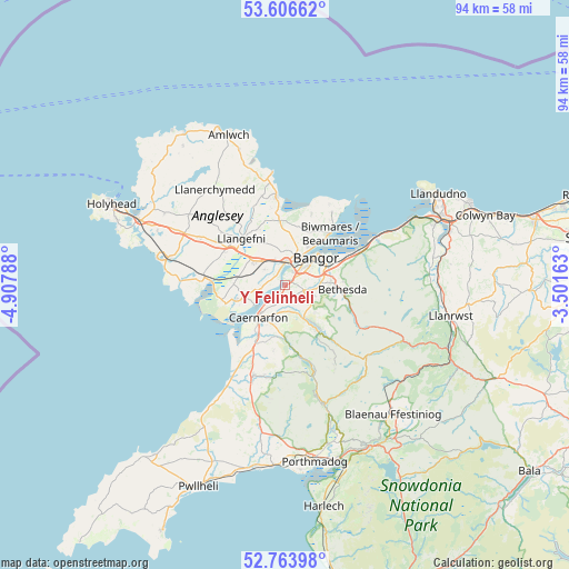
| Upper-left | 53.60662°, | -4.90788° |
| Center: | 53.18737°, | -4.20476° |
| Lower-right: | 52.76398°, | -3.50163° |
| Map W x H: | 93.7×93.7 km | = 58.2×58.2mi |
| max Lat: | 60.39635° ⇑36.4% North |
| Y Felinheli: | 53.18737° |
| min Lat: | ⇓63.6% South 34.60088° |
| min Long | Y Felinheli | max Long |
| -7.64133° | -4.20476° | 32.95536° |
| W 9.5%⇐ | ⇒90.5% E |
Elevation
Elevation of Y Felinheli is 13 m = 43 ft, and this is 59.9 m = 197 ft below average elevation for this country.
| Max E: |
515 m = 1690 ft | 88.2% |
| Avg. | 72.9 m = 239 ft | |
| Y Felinheli | 13 m = 43 ft | |
Min E: |
-30 m = -98 ft | 11.8% |
See also: United Kingdom elevation on elevation.city.
Geographical zone
Y Felinheli is located in North temperate zone (between Tropic of Cancer and the Arctic Circle). Distance of this North polar circle is 1487.3 km =924.2 mi to North.| Distance of | km | miles | from Y Felinheli |
|---|---|---|---|
| North Pole | 4093.2 | 2543.4 | to North |
| Arctic Circle | 1487.3 | 924.2 | to North |
| Tropic Cancer | 3308 | 2055.5 | to South |
| Equator | 5913.9 | 3674.7 | to South |


Nearby cities:
15 places around Y Felinheli: (largest is in red/bold)
• Bangor
6.7 km =4.2 mi,  48°
48°
• Bethesda
9.8 km =6.1 mi,  93°
93°
• Bontnewydd
9 km =5.6 mi,  208°
208°
• Caernarfon
6.7 km =4.2 mi,  220°
220°
• Deiniolen
6.5 km =4 mi,  131°
131°
• Dwyran
8.1 km =5 mi,  253°
253°
• Gaerwen
5.9 km =3.7 mi,  309°
309°
• Llanberis
9.2 km =5.7 mi,  146°
146°
• Llanfairpwllgwyngyll
3.8 km =2.4 mi,  1°
1°
• Llangefni
10.4 km =6.5 mi,  317°
317°
• Llanrug
4.4 km =2.7 mi,  172°
172°
• Llanwnda
10.8 km =6.7 mi, 207°
• Menai Bridge
5.1 km =3.2 mi,  27°
27°
• Pentraeth
10.8 km =6.7 mi,  355°
355°
• Tregarth
7.8 km =4.8 mi, 87°
Sources, notices
• [Note1] Compared only with cities in United Kingdom existing in our database
• [Src1] Map data: © OpenStreetMap contributors (CC-BY-SA)
• [Src2] Other city data from geonames.org with taken over terms of usage.
• [Src3] Geographical zone / Annual Mean Temperature by Robert A. Rohde @ Wikipedia
