New Cumnock geodata
New Cumnock (Scotland) is a populated place; located in United Kingdom in Europe/London (GMT+1) time zone. With population of 2,840 people, there are 2186 cities with bigger population in this country. Compared to other cities in United Kingdom, 88.3% of cities are located further ↓South; 90.4% of cities are located further →East and 95.3% of cities have lower elevation than New Cumnock. Note1


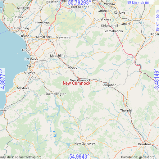
New Cumnock GPS coordinates[2]
55° 23' 44.268" North, 4° 11' 4.488" West
| Map corner | latitude | longitude |
|---|---|---|
| Upper-left | 55.79293°, | -4.88771° |
| Center: | 55.39563°, | -4.18458° |
| Lower-right: | 54.9943°, | -3.48146° |
| Map W x H: | 88.8×88.8 km | = 55.2×55.2mi |
| max Lat: | 60.39635° ⇑11.7% North |
| New Cumnock: | 55.39563° |
| min Lat: | ⇓88.3% South 34.60088° |
| min Long | New Cumnock | max Long |
| -7.64133° | -4.18458° | 32.95536° |
| W 9.6%⇐ | ⇒90.4% E |
Elevation
Elevation of New Cumnock is 187 m = 614 ft, and this is 114.1 m = 374 ft above average elevation for this country.
| Max E: |
515 m = 1690 ft | 4.7% |
| New Cumnock | 187 m 614 ft | |
| Avg. | 72.9 m = 239 ft | |
Min E: |
-30 m = -98 ft | 95.3% |
See also: United Kingdom elevation on elevation.city.
Geographical zone
New Cumnock is located in North temperate zone (between Tropic of Cancer and the Arctic Circle). Distance of this North polar circle is 1241.8 km =771.6 mi to North.| Distance of | km | miles | from New Cumnock |
|---|---|---|---|
| North Pole | 3847.6 | 2390.8 | to North |
| Arctic Circle | 1241.8 | 771.6 | to North |
| Tropic Cancer | 3553.5 | 2208 | to South |
| Equator | 6159.4 | 3827.3 | to South |


Nearby cities:
15 places around New Cumnock: (largest is in red/bold)
• Auchinleck
10.9 km =6.8 mi,  320°
320°
• Bellsbank
16.4 km =10.2 mi,  235°
235°
• Catrine
15.2 km =9.4 mi, 322°
• Coylton
21.8 km =13.5 mi,  284°
284°
• Cumnock
8.3 km =5.2 mi, 321°
• Dalmellington
15.9 km =9.9 mi, 239°
• Drongan
17.7 km =11 mi, 284°
• Hillhead
20.3 km =12.6 mi,  286°
286°
• Kirkconnel
11.8 km =7.3 mi,  95°
95°
• Logan
7.3 km =4.5 mi,  334°
334°
• Mauchline
18.2 km =11.3 mi, 317°
• Muirkirk
16 km =9.9 mi,  27°
27°
• Ochiltree
13.6 km =8.5 mi,  301°
301°
• Patna
20.6 km =12.8 mi,  260°
260°
• Sanquhar
17 km =10.6 mi, 101°
Sources, notices
• [Note1] Compared only with cities in United Kingdom existing in our database
• [Src1] Map data: © OpenStreetMap contributors (CC-BY-SA)
• [Src2] Other city data from geonames.org with taken over terms of usage.
• [Src3] Geographical zone / Annual Mean Temperature by Robert A. Rohde @ Wikipedia
