Muirkirk geodata
Muirkirk (Scotland) is a populated place; located in United Kingdom in Europe/London (GMT+1) time zone. With population of 1,540 people, there are 3003 cities with bigger population in this country. Compared to other cities in United Kingdom, 88.8% of cities are located further ↓South; 88.9% of cities are located further →East and 98.2% of cities have lower elevation than Muirkirk. Note1


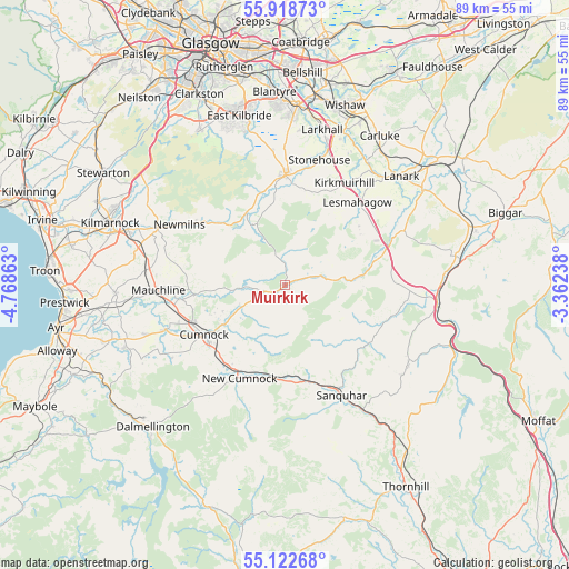
Muirkirk GPS coordinates[2]
55° 31' 21.792" North, 4° 3' 55.836" West
| Map corner | latitude | longitude |
|---|---|---|
| Upper-left | 55.91873°, | -4.76863° |
| Center: | 55.52272°, | -4.06551° |
| Lower-right: | 55.12268°, | -3.36238° |
| Map W x H: | 88.5×88.5 km | = 55×55mi |
| max Lat: | 60.39635° ⇑11.2% North |
| Muirkirk: | 55.52272° |
| min Lat: | ⇓88.8% South 34.60088° |
| min Long | Muirkirk | max Long |
| -7.64133° | -4.06551° | 32.95536° |
| W 11.1%⇐ | ⇒88.9% E |
Elevation
Elevation of Muirkirk is 228 m = 748 ft, and this is 155.1 m = 509 ft above average elevation for this country.
| Max E: |
515 m = 1690 ft | 1.8% |
| Muirkirk | 228 m 748 ft | |
| Avg. | 72.9 m = 239 ft | |
Min E: |
-30 m = -98 ft | 98.2% |
See also: United Kingdom elevation on elevation.city.
Geographical zone
Muirkirk is located in North temperate zone (between Tropic of Cancer and the Arctic Circle). Distance of this North polar circle is 1227.6 km =762.8 mi to North.| Distance of | km | miles | from Muirkirk |
|---|---|---|---|
| North Pole | 3833.5 | 2382 | to North |
| Arctic Circle | 1227.6 | 762.8 | to North |
| Tropic Cancer | 3567.6 | 2216.8 | to South |
| Equator | 6173.5 | 3836 | to South |


Nearby cities:
15 places around Muirkirk: (largest is in red/bold)
• Auchinleck
15.4 km =9.6 mi,  248°
248°
• Blackwood
18.5 km =11.5 mi,  30°
30°
• Catrine
16.8 km =10.4 mi,  262°
262°
• Coalburn
13.7 km =8.5 mi,  55°
55°
• Cumnock
14.8 km =9.2 mi,  239°
239°
• Darvel
16.7 km =10.4 mi,  305°
305°
• Douglas
13.9 km =8.6 mi,  77°
77°
• Kirkconnel
15.8 km =9.8 mi,  164°
164°
• Lesmahagow
16.9 km =10.5 mi,  41°
41°
• Logan
13.1 km =8.1 mi,  234°
234°
• New Cumnock
16 km =9.9 mi,  207°
207°
• Newmilns
18.8 km =11.7 mi,  300°
300°
• Rigside
19.7 km =12.2 mi,  65°
65°
• Stonehouse
19.7 km =12.2 mi,  14°
14°
• Strathaven
17.2 km =10.7 mi,  359°
359°
Sources, notices
• [Note1] Compared only with cities in United Kingdom existing in our database
• [Src1] Map data: © OpenStreetMap contributors (CC-BY-SA)
• [Src2] Other city data from geonames.org with taken over terms of usage.
• [Src3] Geographical zone / Annual Mean Temperature by Robert A. Rohde @ Wikipedia
