Newburn geodata
Newburn (England) is a populated place; located in United Kingdom in Europe/London (GMT+1) time zone. With population of 41,347 people, there are 291 cities with bigger population in this country. Compared to other cities in United Kingdom, 86.6% of cities are located further ↓South; 50% of cities are located further ←West and 64.9% of cities have higher elevation than Newburn. Note1


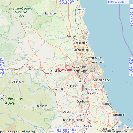
Newburn GPS coordinates[2]
54° 59' 15.36" North, 1° 44' 38.94" West
| Map corner | latitude | longitude |
|---|---|---|
| Upper-left | 55.389°, | -2.44727° |
| Center: | 54.9876°, | -1.74415° |
| Lower-right: | 54.58215°, | -1.04102° |
| Map W x H: | 89.7×89.7 km | = 55.7×55.7mi |
| max Lat: | 60.39635° ⇑13.4% North |
| Newburn: | 54.9876° |
| min Lat: | ⇓86.6% South 34.60088° |
| min Long | Newburn | max Long |
| -7.64133° | -1.74415° | 32.95536° |
| W 50%⇐ | ⇒50% E |
Elevation
Elevation of Newburn is 40 m = 131 ft, and this is 32.9 m = 108 ft below average elevation for this country.
| Max E: |
515 m = 1690 ft | 64.9% |
| Avg. | 72.9 m = 239 ft | |
| Newburn | 40 m = 131 ft | |
Min E: |
-30 m = -98 ft | 35.1% |
See also: Newburn elevation on elevation.city.
Geographical zone
Newburn is located in North temperate zone (between Tropic of Cancer and the Arctic Circle). Distance of this North polar circle is 1287.1 km =799.8 mi to North.| Distance of | km | miles | from Newburn |
|---|---|---|---|
| North Pole | 3893 | 2419 | to North |
| Arctic Circle | 1287.1 | 799.8 | to North |
| Tropic Cancer | 3508.1 | 2179.8 | to South |
| Equator | 6114 | 3799.1 | to South |


Nearby cities:
15 places around Newburn: (largest is in red/bold)
• Benwell
5 km =3.1 mi,  108°
108°
• Blaydon-on-Tyne
3.2 km =2 mi,  142°
142°
• Burnopfield
9.1 km =5.7 mi,  172°
172°
• Darras Hall
5.5 km =3.4 mi,  346°
346°
• Dinnington
8.6 km =5.3 mi,  30°
30°
• Gosforth
8.2 km =5.1 mi,  80°
80°
• Hazlerigg
9 km =5.6 mi,  48°
48°
• Heddon on the Wall
3.3 km =2.1 mi,  288°
288°
• Horsley
6.8 km =4.2 mi,  265°
265°
• Newcastle upon Tyne
8.5 km =5.3 mi,  100°
100°
• Ponteland
7 km =4.3 mi,  359°
359°
• Prudhoe
7.4 km =4.6 mi,  247°
247°
• Rowlands Gill
7.6 km =4.7 mi,  180°
180°
• Whickham
6.4 km =4 mi, 137°
• Wylam
5.1 km =3.2 mi,  256°
256°
Sources, notices
• [Note1] Compared only with cities in United Kingdom existing in our database
• [Src1] Map data: © OpenStreetMap contributors (CC-BY-SA)
• [Src2] Other city data from geonames.org with taken over terms of usage.
• [Src3] Geographical zone / Annual Mean Temperature by Robert A. Rohde @ Wikipedia
