Blaydon-on-Tyne geodata
Blaydon-on-Tyne (England) is a populated place; located in United Kingdom in Europe/London (GMT+1) time zone. With population of 14,974 people, there are 772 cities with bigger population in this country. Compared to other cities in United Kingdom, 86.3% of cities are located further ↓South; 50.6% of cities are located further ←West and 92.6% of cities have higher elevation than Blaydon-on-Tyne. Note1


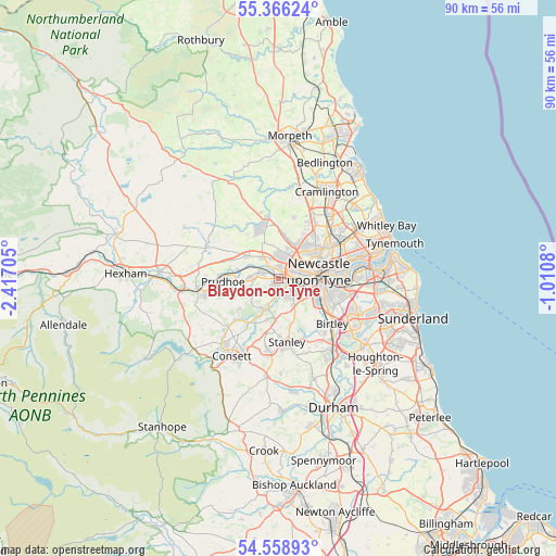
Blaydon-on-Tyne GPS coordinates[2]
54° 57' 52.596" North, 1° 42' 50.112" West
| Map corner | latitude | longitude |
|---|---|---|
| Upper-left | 55.36624°, | -2.41705° |
| Center: | 54.96461°, | -1.71392° |
| Lower-right: | 54.55893°, | -1.0108° |
| Map W x H: | 89.8×89.8 km | = 55.8×55.8mi |
| max Lat: | 60.39635° ⇑13.7% North |
| Blaydon-on-Tyne: | 54.96461° |
| min Lat: | ⇓86.3% South 34.60088° |
| min Long | Blaydon-on-Tyne | max Long |
| -7.64133° | -1.71392° | 32.95536° |
| W 50.6%⇐ | ⇒49.4% E |
Elevation
Elevation of Blaydon-on-Tyne is 10 m = 33 ft, and this is 62.9 m = 206 ft below average elevation for this country.
| Max E: |
515 m = 1690 ft | 92.6% |
| Avg. | 72.9 m = 239 ft | |
| Blaydon-on-Tyne | 10 m = 33 ft | |
Min E: |
-30 m = -98 ft | 7.4% |
See also: United Kingdom elevation on elevation.city.
Geographical zone
Blaydon-on-Tyne is located in North temperate zone (between Tropic of Cancer and the Arctic Circle). Distance of this North polar circle is 1289.7 km =801.4 mi to North.| Distance of | km | miles | from Blaydon-on-Tyne |
|---|---|---|---|
| North Pole | 3895.6 | 2420.6 | to North |
| Arctic Circle | 1289.7 | 801.4 | to North |
| Tropic Cancer | 3505.6 | 2178.3 | to South |
| Equator | 6111.5 | 3797.5 | to South |


Nearby cities:
15 places around Blaydon-on-Tyne: (largest is in red/bold)
• Benwell
3 km =1.9 mi,  71°
71°
• Burnopfield
6.5 km =4 mi,  186°
186°
• Chopwell
8.5 km =5.3 mi,  232°
232°
• Darras Hall
8.5 km =5.3 mi,  337°
337°
• Gateshead
7.2 km =4.5 mi,  92°
92°
• Gosforth
7.3 km =4.5 mi,  57°
57°
• Heddon on the Wall
6.2 km =3.9 mi,  305°
305°
• Lamesley
8.6 km =5.3 mi,  129°
129°
• Newburn
3.2 km =2 mi,  322°
322°
• Newcastle upon Tyne
6.5 km =4 mi,  81°
81°
• Prudhoe
8.8 km =5.5 mi,  267°
267°
• Rowlands Gill
5.4 km =3.4 mi,  201°
201°
• Tanfield
8 km =5 mi,  179°
179°
• Whickham
3.2 km =2 mi, 131°
• Wylam
7 km =4.3 mi,  280°
280°
Sources, notices
• [Note1] Compared only with cities in United Kingdom existing in our database
• [Src1] Map data: © OpenStreetMap contributors (CC-BY-SA)
• [Src2] Other city data from geonames.org with taken over terms of usage.
• [Src3] Geographical zone / Annual Mean Temperature by Robert A. Rohde @ Wikipedia
