Mullion geodata
Mullion (England) is a populated place; located in United Kingdom in Europe/London (GMT+1) time zone. With population of 1,955 people, there are 2660 cities with bigger population in this country. Compared to other cities in United Kingdom, 99.9% of cities are located further ↑North; 97.2% of cities are located further →East and 55.3% of cities have lower elevation than Mullion. Note1


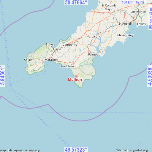
Mullion GPS coordinates[2]
50° 1' 37.416" North, 5° 14' 32.928" West
| Map corner | latitude | longitude |
|---|---|---|
| Upper-left | 50.47664°, | -5.94561° |
| Center: | 50.02706°, | -5.24248° |
| Lower-right: | 49.57323°, | -4.53936° |
| Map W x H: | 100.4×100.4 km | = 62.4×62.4mi |
| max Lat: | 60.39635° ⇑99.9% North |
| Mullion: | 50.02706° |
| min Lat: | ⇓0.1% South 34.60088° |
| min Long | Mullion | max Long |
| -7.64133° | -5.24248° | 32.95536° |
| W 2.8%⇐ | ⇒97.2% E |
Elevation
Elevation of Mullion is 69 m = 226 ft, and this is 3.9 m = 13 ft below average elevation for this country.
| Max E: |
515 m = 1690 ft | 44.7% |
| Avg. | 72.9 m = 239 ft | |
| Mullion | 69 m = 226 ft | |
Min E: |
-30 m = -98 ft | 55.3% |
See also: United Kingdom elevation on elevation.city.
Geographical zone
Mullion is located in North temperate zone (between Tropic of Cancer and the Arctic Circle). Distance of this North polar circle is 1838.7 km =1142.5 mi to North.| Distance of | km | miles | from Mullion |
|---|---|---|---|
| North Pole | 4444.6 | 2761.7 | to North |
| Arctic Circle | 1838.7 | 1142.5 | to North |
| Tropic Cancer | 2956.6 | 1837.1 | to South |
| Equator | 5562.5 | 3456.4 | to South |


Nearby cities:
15 places around Mullion: (largest is in red/bold)
• Constantine
11.3 km =7 mi,  24°
24°
• Falmouth
18.7 km =11.6 mi,  40°
40°
• Flushing
19.7 km =12.2 mi, 38°
• Four Lanes
19.4 km =12.1 mi,  0°
0°
• Germoe
13.8 km =8.6 mi,  315°
315°
• Gweek
8.1 km =5 mi, 18°
• Helston
8.7 km =5.4 mi,  346°
346°
• Landewednack
7.2 km =4.5 mi,  153°
153°
• Lizard
7 km =4.3 mi,  157°
157°
• Marazion
19.9 km =12.4 mi,  303°
303°
• Penryn
18.5 km =11.5 mi,  32°
32°
• Porthleven
8.4 km =5.2 mi, 321°
• Ruan Minor
5.7 km =3.5 mi,  130°
130°
• Stithians
18.6 km =11.6 mi,  14°
14°
• Wendron
11.8 km =7.3 mi,  357°
357°
Sources, notices
• [Note1] Compared only with cities in United Kingdom existing in our database
• [Src1] Map data: © OpenStreetMap contributors (CC-BY-SA)
• [Src2] Other city data from geonames.org with taken over terms of usage.
• [Src3] Geographical zone / Annual Mean Temperature by Robert A. Rohde @ Wikipedia
