Moffat geodata
Moffat (Scotland) is a populated place; located in United Kingdom in Europe/London (GMT+1) time zone. With population of 2,550 people, there are 2311 cities with bigger population in this country. Compared to other cities in United Kingdom, 88.2% of cities are located further ↓South; 81.4% of cities are located further →East and 81.9% of cities have lower elevation than Moffat. Note1


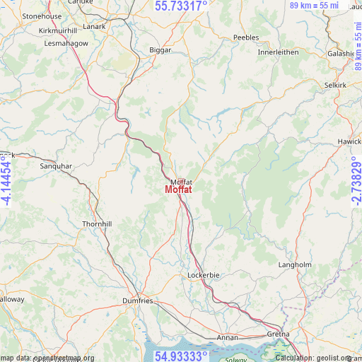
Moffat GPS coordinates[2]
55° 20' 6.972" North, 3° 26' 29.112" West
| Map corner | latitude | longitude |
|---|---|---|
| Upper-left | 55.73317°, | -4.14454° |
| Center: | 55.33527°, | -3.44142° |
| Lower-right: | 54.93333°, | -2.73829° |
| Map W x H: | 88.9×88.9 km | = 55.2×55.2mi |
| max Lat: | 60.39635° ⇑11.8% North |
| Moffat: | 55.33527° |
| min Lat: | ⇓88.2% South 34.60088° |
| min Long | Moffat | max Long |
| -7.64133° | -3.44142° | 32.95536° |
| W 18.6%⇐ | ⇒81.4% E |
Elevation
Elevation of Moffat is 123 m = 404 ft, and this is 50.1 m = 164 ft above average elevation for this country.
| Max E: |
515 m = 1690 ft | 18.1% |
| Moffat | 123 m 404 ft | |
| Avg. | 72.9 m = 239 ft | |
Min E: |
-30 m = -98 ft | 81.9% |
See also: United Kingdom elevation on elevation.city.
Geographical zone
Moffat is located in North temperate zone (between Tropic of Cancer and the Arctic Circle). Distance of this North polar circle is 1248.5 km =775.8 mi to North.| Distance of | km | miles | from Moffat |
|---|---|---|---|
| North Pole | 3854.4 | 2395 | to North |
| Arctic Circle | 1248.5 | 775.8 | to North |
| Tropic Cancer | 3546.8 | 2203.9 | to South |
| Equator | 6152.7 | 3823.1 | to South |


Nearby cities:
15 places around Moffat: (largest is in red/bold)
• Biggar
32.4 km =20.1 mi,  350°
350°
• Cargenbridge
33.6 km =20.9 mi,  202°
202°
• Douglas
35.1 km =21.8 mi,  312°
312°
• Dumfries
31.4 km =19.5 mi, 200°
• Eaglesfield
34.4 km =21.4 mi,  153°
153°
• Ecclefechan
32.6 km =20.3 mi,  160°
160°
• Kirkconnel
35.6 km =22.1 mi,  279°
279°
• Langholm
34.7 km =21.6 mi,  126°
126°
• Locharbriggs
27.3 km =17 mi, 199°
• Lochmaben
22.8 km =14.2 mi,  180°
180°
• Lockerbie
24.2 km =15 mi,  167°
167°
• Sanquhar
30.5 km =19 mi, 276°
• Symington
30.8 km =19.1 mi,  341°
341°
• Thankerton
34.5 km =21.4 mi, 339°
• Thornhill
23.5 km =14.6 mi,  241°
241°
Sources, notices
• [Note1] Compared only with cities in United Kingdom existing in our database
• [Src1] Map data: © OpenStreetMap contributors (CC-BY-SA)
• [Src2] Other city data from geonames.org with taken over terms of usage.
• [Src3] Geographical zone / Annual Mean Temperature by Robert A. Rohde @ Wikipedia
