Melton Mowbray geodata
Melton Mowbray (England) is a populated place; located in United Kingdom in Europe/London (GMT+1) time zone. With population of 27,158 people, there are 445 cities with bigger population in this country. Compared to other cities in United Kingdom, 56.7% of cities are located further ↓South; 68.7% of cities are located further ←West and 61.6% of cities have lower elevation than Melton Mowbray. Note1


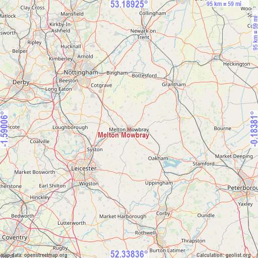
Melton Mowbray GPS coordinates[2]
52° 45' 57.168" North, 0° 53' 12.948" West
| Map corner | latitude | longitude |
|---|---|---|
| Upper-left | 53.18925°, | -1.59006° |
| Center: | 52.76588°, | -0.88693° |
| Lower-right: | 52.33836°, | -0.18381° |
| Map W x H: | 94.6×94.6 km | = 58.8×58.8mi |
| max Lat: | 60.39635° ⇑43.3% North |
| Melton Mowbray: | 52.76588° |
| min Lat: | ⇓56.7% South 34.60088° |
| min Long | Melton Mowbray | max Long |
| -7.64133° | -0.88693° | 32.95536° |
| W 68.7%⇐ | ⇒31.3% E |
Elevation
Elevation of Melton Mowbray is 79 m = 259 ft, and this is 6.1 m = 20 ft above average elevation for this country.
| Max E: |
515 m = 1690 ft | 38.4% |
| Melton Mowbray | 79 m 259 ft | |
| Avg. | 72.9 m = 239 ft | |
Min E: |
-30 m = -98 ft | 61.6% |
See also: United Kingdom elevation on elevation.city.
Geographical zone
Melton Mowbray is located in North temperate zone (between Tropic of Cancer and the Arctic Circle). Distance of this North polar circle is 1534.2 km =953.3 mi to North.| Distance of | km | miles | from Melton Mowbray |
|---|---|---|---|
| North Pole | 4140 | 2572.5 | to North |
| Arctic Circle | 1534.2 | 953.3 | to North |
| Tropic Cancer | 3261.1 | 2026.4 | to South |
| Equator | 5867 | 3645.6 | to South |


Nearby cities:
15 places around Melton Mowbray: (largest is in red/bold)
• Asfordby
4.8 km =3 mi,  266°
266°
• Ashwell
12.7 km =7.9 mi,  117°
117°
• Great Dalby
4.9 km =3 mi,  190°
190°
• Grimston
7.2 km =4.5 mi,  291°
291°
• Harby
11.9 km =7.4 mi,  357°
357°
• Hose
10.2 km =6.3 mi,  353°
353°
• Langham
12.2 km =7.6 mi,  132°
132°
• Long Clawson
8.4 km =5.2 mi,  340°
340°
• Queniborough
12.7 km =7.9 mi,  238°
238°
• Somerby
9.1 km =5.7 mi,  164°
164°
• Stathern
12 km =7.5 mi,  10°
10°
• Thrussington
10.9 km =6.8 mi,  252°
252°
• Waltham on the Wolds
7.8 km =4.8 mi,  42°
42°
• Willoughby on the Wolds
12.9 km =8 mi,  298°
298°
• Wymondham
9.9 km =6.2 mi,  93°
93°
Sources, notices
• [Note1] Compared only with cities in United Kingdom existing in our database
• [Src1] Map data: © OpenStreetMap contributors (CC-BY-SA)
• [Src2] Other city data from geonames.org with taken over terms of usage.
• [Src3] Geographical zone / Annual Mean Temperature by Robert A. Rohde @ Wikipedia
