Manchester geodata
Manchester (England) is a seat of a second-order administrative division; located in United Kingdom in Europe/London (GMT+1) time zone. With population of 395,515 people, there are 11 cities with bigger population in this country. Compared to other cities in United Kingdom, 69.4% of cities are located further ↓South; 60.1% of cities are located further →East and 56.8% of cities have higher elevation than Manchester. Note1


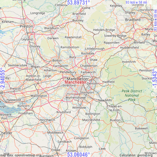
Manchester GPS coordinates[2]
53° 28' 51.42" North, 2° 14' 14.748" West
| Map corner | latitude | longitude |
|---|---|---|
| Upper-left | 53.89731°, | -2.94055° |
| Center: | 53.48095°, | -2.23743° |
| Lower-right: | 53.06046°, | -1.5343° |
| Map W x H: | 93×93 km | = 57.8×57.8mi |
| max Lat: | 60.39635° ⇑30.6% North |
| Manchester: | 53.48095° |
| min Lat: | ⇓69.4% South 34.60088° |
| min Long | Manchester | max Long |
| -7.64133° | -2.23743° | 32.95536° |
| W 39.9%⇐ | ⇒60.1% E |
Elevation
Elevation of Manchester is 51 m = 167 ft, and this is 21.9 m = 72 ft below average elevation for this country.
| Max E: |
515 m = 1690 ft | 56.8% |
| Avg. | 72.9 m = 239 ft | |
| Manchester | 51 m = 167 ft | |
Min E: |
-30 m = -98 ft | 43.2% |
See also: Manchester elevation on elevation.city.
Geographical zone
Manchester is located in North temperate zone (between Tropic of Cancer and the Arctic Circle). Distance of this North polar circle is 1454.6 km =903.8 mi to North.| Distance of | km | miles | from Manchester |
|---|---|---|---|
| North Pole | 4060.5 | 2523.1 | to North |
| Arctic Circle | 1454.6 | 903.8 | to North |
| Tropic Cancer | 3340.6 | 2075.8 | to South |
| Equator | 5946.5 | 3695 | to South |


Nearby cities:
15 places around Manchester: (largest is in red/bold)
• Blackley
4.4 km =2.7 mi,  20°
20°
• Burnage
5.9 km =3.7 mi,  155°
155°
• Cheetham Hill
2 km =1.2 mi,  358°
358°
• Chorlton cum Hardy
5.4 km =3.4 mi,  198°
198°
• Crumpsall
4.2 km =2.6 mi,  353°
353°
• Droylsden
6.1 km =3.8 mi,  90°
90°
• Eccles
6.4 km =4 mi,  272°
272°
• Failsworth
5.4 km =3.4 mi,  60°
60°
• Fallowfield
4.8 km =3 mi, 162°
• Hulme
1.9 km =1.2 mi, 204°
• Longsight
3.5 km =2.2 mi,  136°
136°
• Prestwich
6.6 km =4.1 mi,  332°
332°
• Salford
3.6 km =2.2 mi,  282°
282°
• Stretford
6.3 km =3.9 mi,  236°
236°
• Trafford Park
5.1 km =3.2 mi,  254°
254°
Sources, notices
• [Note1] Compared only with cities in United Kingdom existing in our database
• [Src1] Map data: © OpenStreetMap contributors (CC-BY-SA)
• [Src2] Other city data from geonames.org with taken over terms of usage.
• [Src3] Geographical zone / Annual Mean Temperature by Robert A. Rohde @ Wikipedia
