Salford geodata
Salford (England) is a seat of a second-order administrative division; located in United Kingdom in Europe/London (GMT+1) time zone. With population of 72,750 people, there are 144 cities with bigger population in this country. Compared to other cities in United Kingdom, 69.6% of cities are located further ↓South; 61.2% of cities are located further →East and 61.7% of cities have higher elevation than Salford. Note1


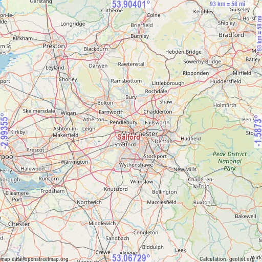
Salford GPS coordinates[2]
53° 29' 15.756" North, 2° 17' 25.512" West
| Map corner | latitude | longitude |
|---|---|---|
| Upper-left | 53.90401°, | -2.99355° |
| Center: | 53.48771°, | -2.29042° |
| Lower-right: | 53.06729°, | -1.5873° |
| Map W x H: | 93×93 km | = 57.8×57.8mi |
| max Lat: | 60.39635° ⇑30.4% North |
| Salford: | 53.48771° |
| min Lat: | ⇓69.6% South 34.60088° |
| min Long | Salford | max Long |
| -7.64133° | -2.29042° | 32.95536° |
| W 38.8%⇐ | ⇒61.2% E |
Elevation
Elevation of Salford is 44 m = 144 ft, and this is 28.9 m = 95 ft below average elevation for this country.
| Max E: |
515 m = 1690 ft | 61.7% |
| Avg. | 72.9 m = 239 ft | |
| Salford | 44 m = 144 ft | |
Min E: |
-30 m = -98 ft | 38.3% |
See also: Salford elevation on elevation.city.
Geographical zone
Salford is located in North temperate zone (between Tropic of Cancer and the Arctic Circle). Distance of this North polar circle is 1453.9 km =903.4 mi to North.| Distance of | km | miles | from Salford |
|---|---|---|---|
| North Pole | 4059.8 | 2522.6 | to North |
| Arctic Circle | 1453.9 | 903.4 | to North |
| Tropic Cancer | 3341.4 | 2076.2 | to South |
| Equator | 5947.3 | 3695.5 | to South |


Nearby cities:
15 places around Salford: (largest is in red/bold)
• Blackley
6 km =3.7 mi,  56°
56°
• Cheetham Hill
3.6 km =2.2 mi,  70°
70°
• Chorlton cum Hardy
6.1 km =3.8 mi,  162°
162°
• Crumpsall
4.6 km =2.9 mi,  41°
41°
• Eccles
2.9 km =1.8 mi,  260°
260°
• Hulme
3.7 km =2.3 mi,  131°
131°
• Longsight
6.8 km =4.2 mi,  119°
119°
• Manchester
3.6 km =2.2 mi,  102°
102°
• Prestwich
5.1 km =3.2 mi,  5°
5°
• Simister
7.2 km =4.5 mi,  18°
18°
• Stretford
4.5 km =2.8 mi,  202°
202°
• Swinton
4.2 km =2.6 mi,  289°
289°
• Trafford Park
2.5 km =1.6 mi,  214°
214°
• Urmston
6.1 km =3.8 mi,  224°
224°
• Whitefield
7 km =4.3 mi,  354°
354°
Sources, notices
• [Note1] Compared only with cities in United Kingdom existing in our database
• [Src1] Map data: © OpenStreetMap contributors (CC-BY-SA)
• [Src2] Other city data from geonames.org with taken over terms of usage.
• [Src3] Geographical zone / Annual Mean Temperature by Robert A. Rohde @ Wikipedia
