Macclesfield geodata
Macclesfield (England) is a populated place; located in United Kingdom in Europe/London (GMT+1) time zone. With population of 63,954 people, there are 166 cities with bigger population in this country. Compared to other cities in United Kingdom, 65.1% of cities are located further ↓South; 57.4% of cities are located further →East and 91.1% of cities have lower elevation than Macclesfield. Note1


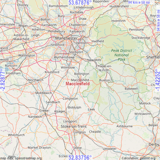
Macclesfield GPS coordinates[2]
53° 15' 36.828" North, 2° 7' 32.304" West
| Map corner | latitude | longitude |
|---|---|---|
| Upper-left | 53.67876°, | -2.82877° |
| Center: | 53.26023°, | -2.12564° |
| Lower-right: | 52.83756°, | -1.42252° |
| Map W x H: | 93.5×93.5 km | = 58.1×58.1mi |
| max Lat: | 60.39635° ⇑34.9% North |
| Macclesfield: | 53.26023° |
| min Lat: | ⇓65.1% South 34.60088° |
| min Long | Macclesfield | max Long |
| -7.64133° | -2.12564° | 32.95536° |
| W 42.6%⇐ | ⇒57.4% E |
Elevation
Elevation of Macclesfield is 156 m = 512 ft, and this is 83.1 m = 273 ft above average elevation for this country.
| Max E: |
515 m = 1690 ft | 8.9% |
| Macclesfield | 156 m 512 ft | |
| Avg. | 72.9 m = 239 ft | |
Min E: |
-30 m = -98 ft | 91.1% |
See also: Macclesfield elevation on elevation.city.
Geographical zone
Macclesfield is located in North temperate zone (between Tropic of Cancer and the Arctic Circle). Distance of this North polar circle is 1479.2 km =919.1 mi to North.| Distance of | km | miles | from Macclesfield |
|---|---|---|---|
| North Pole | 4085.1 | 2538.4 | to North |
| Arctic Circle | 1479.2 | 919.1 | to North |
| Tropic Cancer | 3316.1 | 2060.5 | to South |
| Equator | 5922 | 3679.8 | to South |


Nearby cities:
15 places around Macclesfield: (largest is in red/bold)
• Adlington
6.7 km =4.2 mi,  353°
353°
• Alderley Edge
8.9 km =5.5 mi,  303°
303°
• Bollington
4 km =2.5 mi,  15°
15°
• Bramhall
11.2 km =7 mi, 346°
• Chelford
10.6 km =6.6 mi,  276°
276°
• Congleton
12.2 km =7.6 mi,  208°
208°
• Eaton
9.9 km =6.2 mi, 210°
• Gawsworth
4.3 km =2.7 mi,  223°
223°
• Mottram St. Andrew
6.3 km =3.9 mi,  323°
323°
• Pott Shrigley
6.1 km =3.8 mi,  26°
26°
• Poynton
10 km =6.2 mi,  3°
3°
• Prestbury
3 km =1.9 mi,  327°
327°
• Siddington
7.8 km =4.8 mi,  247°
247°
• Whaley Bridge
12.3 km =7.6 mi,  50°
50°
• Wilmslow
10.3 km =6.4 mi, 316°
Sources, notices
• [Note1] Compared only with cities in United Kingdom existing in our database
• [Src1] Map data: © OpenStreetMap contributors (CC-BY-SA)
• [Src2] Other city data from geonames.org with taken over terms of usage.
• [Src3] Geographical zone / Annual Mean Temperature by Robert A. Rohde @ Wikipedia
