Adlington geodata
Adlington (England) is a seat of a third-order administrative division; located in United Kingdom in Europe/London (GMT+1) time zone. With population of 1,081 people, there are 3525 cities with bigger population in this country. Compared to other cities in United Kingdom, 66.4% of cities are located further ↓South; 57.7% of cities are located further →East and 74.6% of cities have lower elevation than Adlington. Note1


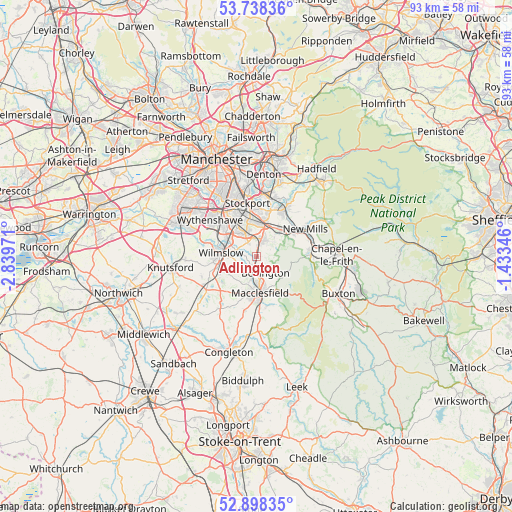
Adlington GPS coordinates[2]
53° 19' 13.512" North, 2° 8' 11.688" West
| Map corner | latitude | longitude |
|---|---|---|
| Upper-left | 53.73836°, | -2.83971° |
| Center: | 53.32042°, | -2.13658° |
| Lower-right: | 52.89835°, | -1.43346° |
| Map W x H: | 93.4×93.4 km | = 58×58mi |
| max Lat: | 60.39635° ⇑33.6% North |
| Adlington: | 53.32042° |
| min Lat: | ⇓66.4% South 34.60088° |
| min Long | Adlington | max Long |
| -7.64133° | -2.13658° | 32.95536° |
| W 42.3%⇐ | ⇒57.7% E |
Elevation
Elevation of Adlington is 105 m = 344 ft, and this is 32.1 m = 105 ft above average elevation for this country.
| Max E: |
515 m = 1690 ft | 25.4% |
| Adlington | 105 m 344 ft | |
| Avg. | 72.9 m = 239 ft | |
Min E: |
-30 m = -98 ft | 74.6% |
See also: United Kingdom elevation on elevation.city.
Geographical zone
Adlington is located in North temperate zone (between Tropic of Cancer and the Arctic Circle). Distance of this North polar circle is 1472.5 km =915 mi to North.| Distance of | km | miles | from Adlington |
|---|---|---|---|
| North Pole | 4078.4 | 2534.2 | to North |
| Arctic Circle | 1472.5 | 915 | to North |
| Tropic Cancer | 3322.8 | 2064.7 | to South |
| Equator | 5928.7 | 3683.9 | to South |


Nearby cities:
15 places around Adlington: (largest is in red/bold)
• Alderley Edge
7 km =4.3 mi,  254°
254°
• Bollington
3.4 km =2.1 mi,  148°
148°
• Bramhall
4.6 km =2.9 mi,  335°
335°
• Cheadle Heath
9.7 km =6 mi, 338°
• Cheadle Hulme
7.1 km =4.4 mi,  330°
330°
• Disley
7.8 km =4.8 mi,  56°
56°
• Hazel Grove
7.1 km =4.4 mi,  10°
10°
• Macclesfield
6.7 km =4.2 mi,  173°
173°
• Marple
9.6 km =6 mi,  30°
30°
• Mottram St. Andrew
3.4 km =2.1 mi,  241°
241°
• Pott Shrigley
3.7 km =2.3 mi,  109°
109°
• Poynton
3.5 km =2.2 mi,  21°
21°
• Prestbury
4.2 km =2.6 mi,  192°
192°
• Stockport
10 km =6.2 mi,  352°
352°
• Wilmslow
6.4 km =4 mi,  277°
277°
Sources, notices
• [Note1] Compared only with cities in United Kingdom existing in our database
• [Src1] Map data: © OpenStreetMap contributors (CC-BY-SA)
• [Src2] Other city data from geonames.org with taken over terms of usage.
• [Src3] Geographical zone / Annual Mean Temperature by Robert A. Rohde @ Wikipedia
