Lydham geodata
Lydham (England) is a seat of a third-order administrative division; located in United Kingdom in Europe/London (GMT+1) time zone. In our database, there are 4977 cities with bigger population. Compared to other cities in United Kingdom, 50.5% of cities are located further ↓South; 74.9% of cities are located further →East and 94.7% of cities have lower elevation than Lydham. Note1


Lydham GPS coordinates[2]
52° 30' 53.136" North, 2° 58' 46.92" West
| Map corner | latitude | longitude |
|---|---|---|
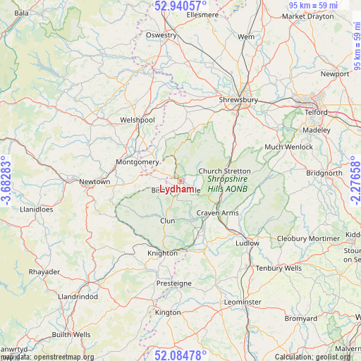
| Upper-left | 52.94057°, | -3.68283° |
| Center: | 52.51476°, | -2.9797° |
| Lower-right: | 52.08478°, | -2.27658° |
| Map W x H: | 95.2×95.2 km | = 59.2×59.2mi |
| max Lat: | 60.39635° ⇑49.5% North |
| Lydham: | 52.51476° |
| min Lat: | ⇓50.5% South 34.60088° |
| min Long | Lydham | max Long |
| -7.64133° | -2.9797° | 32.95536° |
| W 25.1%⇐ | ⇒74.9% E |
Elevation
Elevation of Lydham is 182 m = 597 ft, and this is 109.1 m = 358 ft above average elevation for this country.
| Max E: |
515 m = 1690 ft | 5.3% |
| Lydham | 182 m 597 ft | |
| Avg. | 72.9 m = 239 ft | |
Min E: |
-30 m = -98 ft | 94.7% |
See also: United Kingdom elevation on elevation.city.
Geographical zone
Lydham is located in North temperate zone (between Tropic of Cancer and the Arctic Circle). Distance of this North polar circle is 1562.1 km =970.6 mi to North.| Distance of | km | miles | from Lydham |
|---|---|---|---|
| North Pole | 4168 | 2589.9 | to North |
| Arctic Circle | 1562.1 | 970.6 | to North |
| Tropic Cancer | 3233.2 | 2009 | to South |
| Equator | 5839.1 | 3628.2 | to South |


Nearby cities:
15 places around Lydham: (largest is in red/bold)
• Abermule
17.7 km =11 mi,  280°
280°
• Acton
7.6 km =4.7 mi,  199°
199°
• Bishop's Castle
2.9 km =1.8 mi,  211°
211°
• Bucknell
17.3 km =10.7 mi,  173°
173°
• Cardington
17.1 km =10.6 mi,  76°
76°
• Church Stretton
12.3 km =7.6 mi, 78°
• Clun
10.9 km =6.8 mi, 197°
• Craven Arms
12.6 km =7.8 mi,  129°
129°
• Forden
14.8 km =9.2 mi,  318°
318°
• Longnor
18.2 km =11.3 mi,  58°
58°
• Mainstone
7.8 km =4.8 mi,  243°
243°
• Minsterley
14.3 km =8.9 mi,  14°
14°
• Montgomery
12.4 km =7.7 mi,  294°
294°
• Norbury
2.9 km =1.8 mi,  44°
44°
• Pontesbury
16 km =9.9 mi,  22°
22°
Sources, notices
• [Note1] Compared only with cities in United Kingdom existing in our database
• [Src1] Map data: © OpenStreetMap contributors (CC-BY-SA)
• [Src2] Other city data from geonames.org with taken over terms of usage.
• [Src3] Geographical zone / Annual Mean Temperature by Robert A. Rohde @ Wikipedia
