Luton geodata
Luton (England) is a seat of a second-order administrative division; located in United Kingdom in Europe/London (GMT+1) time zone. With population of 258,018 people, there are 28 cities with bigger population in this country. Compared to other cities in United Kingdom, 65.5% of cities are located further ↑North; 78.5% of cities are located further ←West and 79.7% of cities have lower elevation than Luton. Note1


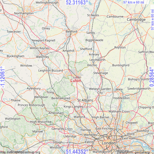
Luton GPS coordinates[2]
51° 52' 46.812" North, 0° 25' 2.928" West
| Map corner | latitude | longitude |
|---|---|---|
| Upper-left | 52.31163°, | -1.12061° |
| Center: | 51.87967°, | -0.41748° |
| Lower-right: | 51.44352°, | 0.28564° |
| Map W x H: | 96.5×96.5 km | = 60×60mi |
| max Lat: | 60.39635° ⇑65.5% North |
| Luton: | 51.87967° |
| min Lat: | ⇓34.5% South 34.60088° |
| min Long | Luton | max Long |
| -7.64133° | -0.41748° | 32.95536° |
| W 78.5%⇐ | ⇒21.5% E |
Elevation
Elevation of Luton is 117 m = 384 ft, and this is 44.1 m = 145 ft above average elevation for this country.
| Max E: |
515 m = 1690 ft | 20.3% |
| Luton | 117 m 384 ft | |
| Avg. | 72.9 m = 239 ft | |
Min E: |
-30 m = -98 ft | 79.7% |
See also: Luton elevation on elevation.city.
Geographical zone
Luton is located in North temperate zone (between Tropic of Cancer and the Arctic Circle). Distance of this North polar circle is 1632.7 km =1014.5 mi to North.| Distance of | km | miles | from Luton |
|---|---|---|---|
| North Pole | 4238.6 | 2633.7 | to North |
| Arctic Circle | 1632.7 | 1014.5 | to North |
| Tropic Cancer | 3162.6 | 1965.1 | to South |
| Equator | 5768.5 | 3584.4 | to South |


Nearby cities:
15 places around Luton: (largest is in red/bold)
• Barton-le-Clay
9.6 km =6 mi,  355°
355°
• Caddington
3.1 km =1.9 mi,  240°
240°
• Chalgrave
10.2 km =6.3 mi,  307°
307°
• Chalton
7.9 km =4.9 mi, 312°
• Dunstable
7.3 km =4.5 mi,  275°
275°
• Flamstead
6.8 km =4.2 mi,  191°
191°
• Great Offley
7.7 km =4.8 mi,  46°
46°
• Harlington
10.6 km =6.6 mi,  330°
330°
• Harpenden
8.1 km =5 mi,  149°
149°
• Houghton Regis
7.6 km =4.7 mi,  291°
291°
• Kensworth
6.7 km =4.2 mi, 242°
• Kimpton
8.7 km =5.4 mi,  111°
111°
• Markyate
5.6 km =3.5 mi,  214°
214°
• Redbourn
9.1 km =5.7 mi,  170°
170°
• Streatley
7.6 km =4.7 mi,  346°
346°
Sources, notices
• [Note1] Compared only with cities in United Kingdom existing in our database
• [Src1] Map data: © OpenStreetMap contributors (CC-BY-SA)
• [Src2] Other city data from geonames.org with taken over terms of usage.
• [Src3] Geographical zone / Annual Mean Temperature by Robert A. Rohde @ Wikipedia
