Long Itchington geodata
Long Itchington (England) is a populated place; located in United Kingdom in Europe/London (GMT+1) time zone. With population of 1,683 people, there are 2874 cities with bigger population in this country. Compared to other cities in United Kingdom, 54.3% of cities are located further ↑North; 57.9% of cities are located further ←West and 59% of cities have lower elevation than Long Itchington. Note1
Administrative division(s):
- Level 1: England
- Level 2: Warwickshire
- Level 3: Stratford-on-Avon District
- Level 4: Long Itchington


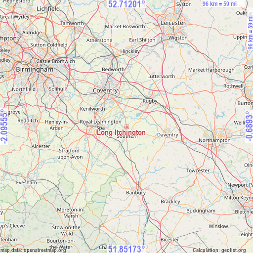
Long Itchington GPS coordinates[2]
52° 17' 2.256" North, 1° 23' 32.748" West
| Map corner | latitude | longitude |
|---|---|---|
| Upper-left | 52.71201°, | -2.09555° |
| Center: | 52.28396°, | -1.39243° |
| Lower-right: | 51.85173°, | -0.6893° |
| Map W x H: | 95.7×95.7 km | = 59.5×59.5mi |
| max Lat: | 60.39635° ⇑54.3% North |
| Long Itchington: | 52.28396° |
| min Lat: | ⇓45.7% South 34.60088° |
| min Long | Long Itchington | max Long |
| -7.64133° | -1.39243° | 32.95536° |
| W 57.9%⇐ | ⇒42.1% E |
Elevation
Elevation of Long Itchington is 75 m = 246 ft, and this is 2.1 m = 7 ft above average elevation for this country.
| Max E: |
515 m = 1690 ft | 41% |
| Long Itchington | 75 m 246 ft | |
| Avg. | 72.9 m = 239 ft | |
Min E: |
-30 m = -98 ft | 59% |
See also: United Kingdom elevation on elevation.city.
Geographical zone
Long Itchington is located in North temperate zone (between Tropic of Cancer and the Arctic Circle). Distance of this North polar circle is 1587.7 km =986.6 mi to North.| Distance of | km | miles | from Long Itchington |
|---|---|---|---|
| North Pole | 4193.6 | 2605.8 | to North |
| Arctic Circle | 1587.7 | 986.6 | to North |
| Tropic Cancer | 3207.5 | 1993 | to South |
| Equator | 5813.4 | 3612.3 | to South |


Nearby cities:
15 places around Long Itchington: (largest is in red/bold)
• Brandon
11.2 km =7 mi,  357°
357°
• Braunston
12.9 km =8 mi,  87°
87°
• Bubbenhall
8.7 km =5.4 mi,  324°
324°
• Dunchurch
9.1 km =5.7 mi,  49°
49°
• Fenny Compton
13 km =8.1 mi,  179°
179°
• Harbury
7 km =4.3 mi,  219°
219°
• Long Lawford
12.3 km =7.6 mi,  28°
28°
• Napton on the Hill
6.4 km =4 mi,  127°
127°
• Priors Marston
10.7 km =6.6 mi,  137°
137°
• Royal Leamington Spa
8.7 km =5.4 mi,  270°
270°
• Rugby
13 km =8.1 mi,  42°
42°
• Ryton on Dunsmore
9.6 km =6 mi,  343°
343°
• Southam
3.5 km =2.2 mi, 175°
• Stockton
2.6 km =1.6 mi,  121°
121°
• Wolston
10.4 km =6.5 mi, 358°
Sources, notices
• [Note1] Compared only with cities in United Kingdom existing in our database
• [Src1] Map data: © OpenStreetMap contributors (CC-BY-SA)
• [Src2] Other city data from geonames.org with taken over terms of usage.
• [Src3] Geographical zone / Annual Mean Temperature by Robert A. Rohde @ Wikipedia
