Loddiswell geodata
Loddiswell (England) is a populated place; located in United Kingdom in Europe/London (GMT+1) time zone. With population of 777 people, there are 4080 cities with bigger population in this country. Compared to other cities in United Kingdom, 99% of cities are located further ↑North; 85.8% of cities are located further →East and 66.5% of cities have lower elevation than Loddiswell. Note1
Administrative division(s):
- Level 1: England
- Level 2: Devon
- Level 3: South Hams District
- Level 4: Loddiswell


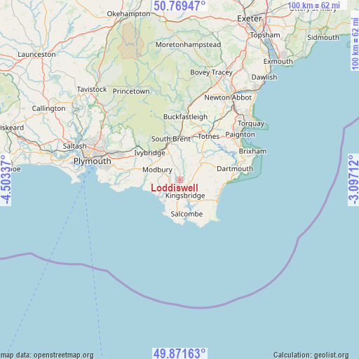
Loddiswell GPS coordinates[2]
50° 19' 21.612" North, 3° 48' 0.864" West
| Map corner | latitude | longitude |
|---|---|---|
| Upper-left | 50.76947°, | -4.50337° |
| Center: | 50.32267°, | -3.80024° |
| Lower-right: | 49.87163°, | -3.09712° |
| Map W x H: | 99.8×99.8 km | = 62×62mi |
| max Lat: | 60.39635° ⇑99% North |
| Loddiswell: | 50.32267° |
| min Lat: | ⇓1% South 34.60088° |
| min Long | Loddiswell | max Long |
| -7.64133° | -3.80024° | 32.95536° |
| W 14.2%⇐ | ⇒85.8% E |
Elevation
Elevation of Loddiswell is 89 m = 292 ft, and this is 16.1 m = 53 ft above average elevation for this country.
| Max E: |
515 m = 1690 ft | 33.5% |
| Loddiswell | 89 m 292 ft | |
| Avg. | 72.9 m = 239 ft | |
Min E: |
-30 m = -98 ft | 66.5% |
See also: United Kingdom elevation on elevation.city.
Geographical zone
Loddiswell is located in North temperate zone (between Tropic of Cancer and the Arctic Circle). Distance of this North polar circle is 1805.8 km =1122.1 mi to North.| Distance of | km | miles | from Loddiswell |
|---|---|---|---|
| North Pole | 4411.7 | 2741.3 | to North |
| Arctic Circle | 1805.8 | 1122.1 | to North |
| Tropic Cancer | 2989.4 | 1857.5 | to South |
| Equator | 5595.4 | 3476.8 | to South |


Nearby cities:
15 places around Loddiswell: (largest is in red/bold)
• Brixton
16.8 km =10.4 mi,  280°
280°
• Dartington
15 km =9.3 mi,  25°
25°
• Dartmouth
16 km =9.9 mi,  78°
78°
• Ivybridge
11.3 km =7 mi,  311°
311°
• Kingsbridge
4.6 km =2.9 mi,  158°
158°
• Malborough
8.9 km =5.5 mi,  185°
185°
• Modbury
6.8 km =4.2 mi,  295°
295°
• Newton Ferrers
17 km =10.6 mi,  266°
266°
• Salcombe
9.7 km =6 mi,  166°
166°
• South Brent
11.8 km =7.3 mi,  348°
348°
• Stoke Fleming
14.3 km =8.9 mi,  88°
88°
• Stoke Gabriel
15.5 km =9.6 mi,  54°
54°
• Thurlestone
7.4 km =4.6 mi,  216°
216°
• Totnes
14.6 km =9.1 mi, 34°
• Yealmpton
14.4 km =8.9 mi, 281°
Sources, notices
• [Note1] Compared only with cities in United Kingdom existing in our database
• [Src1] Map data: © OpenStreetMap contributors (CC-BY-SA)
• [Src2] Other city data from geonames.org with taken over terms of usage.
• [Src3] Geographical zone / Annual Mean Temperature by Robert A. Rohde @ Wikipedia
