Newton Ferrers geodata
Newton Ferrers (England) is a populated place; located in United Kingdom in Europe/London (GMT+1) time zone. With population of 1,268 people, there are 3278 cities with bigger population in this country. Compared to other cities in United Kingdom, 99% of cities are located further ↑North; 88.4% of cities are located further →East and 68.3% of cities have higher elevation than Newton Ferrers. Note1
Administrative division(s):
- Level 1: England
- Level 2: Devon
- Level 3: South Hams District
- Level 4: Newton and Noss


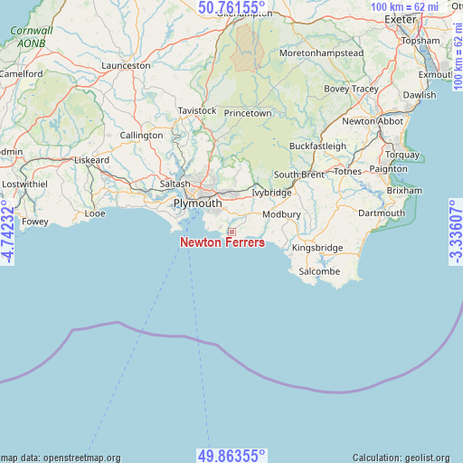
Newton Ferrers GPS coordinates[2]
50° 18' 52.812" North, 4° 2' 21.12" West
| Map corner | latitude | longitude |
|---|---|---|
| Upper-left | 50.76155°, | -4.74232° |
| Center: | 50.31467°, | -4.0392° |
| Lower-right: | 49.86355°, | -3.33607° |
| Map W x H: | 99.8×99.8 km | = 62×62mi |
| max Lat: | 60.39635° ⇑99% North |
| Newton Ferrers: | 50.31467° |
| min Lat: | ⇓1% South 34.60088° |
| min Long | Newton Ferrers | max Long |
| -7.64133° | -4.0392° | 32.95536° |
| W 11.6%⇐ | ⇒88.4% E |
Elevation
Elevation of Newton Ferrers is 35 m = 115 ft, and this is 37.9 m = 124 ft below average elevation for this country.
| Max E: |
515 m = 1690 ft | 68.3% |
| Avg. | 72.9 m = 239 ft | |
| Newton Ferrers | 35 m = 115 ft | |
Min E: |
-30 m = -98 ft | 31.7% |
See also: United Kingdom elevation on elevation.city.
Geographical zone
Newton Ferrers is located in North temperate zone (between Tropic of Cancer and the Arctic Circle). Distance of this North polar circle is 1806.7 km =1122.6 mi to North.| Distance of | km | miles | from Newton Ferrers |
|---|---|---|---|
| North Pole | 4412.6 | 2741.9 | to North |
| Arctic Circle | 1806.7 | 1122.6 | to North |
| Tropic Cancer | 2988.5 | 1857 | to South |
| Equator | 5594.5 | 3476.3 | to South |


Nearby cities:
15 places around Newton Ferrers: (largest is in red/bold)
• Brixton
4 km =2.5 mi,  6°
6°
• Ivybridge
12 km =7.5 mi,  45°
45°
• Kingsbridge
19 km =11.8 mi,  100°
100°
• Loddiswell
17 km =10.6 mi,  86°
86°
• Malborough
18 km =11.2 mi,  116°
116°
• Millbrook
13.1 km =8.1 mi,  287°
287°
• Modbury
11.5 km =7.1 mi,  70°
70°
• Plymouth
9.7 km =6 mi,  310°
310°
• Plympton
8.6 km =5.3 mi,  350°
350°
• Plymstock
6.2 km =3.9 mi,  324°
324°
• Saltash
16.9 km =10.5 mi, 308°
• Thurlestone
13.5 km =8.4 mi,  111°
111°
• Torpoint
13 km =8.1 mi,  301°
301°
• Wembury
2.7 km =1.7 mi, 289°
• Yealmpton
4.7 km =2.9 mi,  37°
37°
Sources, notices
• [Note1] Compared only with cities in United Kingdom existing in our database
• [Src1] Map data: © OpenStreetMap contributors (CC-BY-SA)
• [Src2] Other city data from geonames.org with taken over terms of usage.
• [Src3] Geographical zone / Annual Mean Temperature by Robert A. Rohde @ Wikipedia
