Llanddowror geodata
Llanddowror (Wales) is a seat of a third-order administrative division; located in United Kingdom in Europe/London (GMT+1) time zone. In our database, there are 4977 cities with bigger population. Compared to other cities in United Kingdom, 67.8% of cities are located further ↑North; 93.6% of cities are located further →East and 93.6% of cities have higher elevation than Llanddowror. Note1


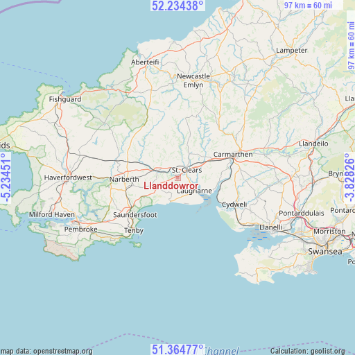
Llanddowror GPS coordinates[2]
51° 48' 6.012" North, 4° 31' 53.004" West
| Map corner | latitude | longitude |
|---|---|---|
| Upper-left | 52.23438°, | -5.23451° |
| Center: | 51.80167°, | -4.53139° |
| Lower-right: | 51.36477°, | -3.82826° |
| Map W x H: | 96.7×96.7 km | = 60.1×60.1mi |
| max Lat: | 60.39635° ⇑67.8% North |
| Llanddowror: | 51.80167° |
| min Lat: | ⇓32.2% South 34.60088° |
| min Long | Llanddowror | max Long |
| -7.64133° | -4.53139° | 32.95536° |
| W 6.4%⇐ | ⇒93.6% E |
Elevation
Elevation of Llanddowror is 9 m = 30 ft, and this is 63.9 m = 210 ft below average elevation for this country.
| Max E: |
515 m = 1690 ft | 93.6% |
| Avg. | 72.9 m = 239 ft | |
| Llanddowror | 9 m = 30 ft | |
Min E: |
-30 m = -98 ft | 6.4% |
See also: United Kingdom elevation on elevation.city.
Geographical zone
Llanddowror is located in North temperate zone (between Tropic of Cancer and the Arctic Circle). Distance of this North polar circle is 1641.4 km =1019.9 mi to North.| Distance of | km | miles | from Llanddowror |
|---|---|---|---|
| North Pole | 4247.3 | 2639.1 | to North |
| Arctic Circle | 1641.4 | 1019.9 | to North |
| Tropic Cancer | 3153.9 | 1959.7 | to South |
| Equator | 5759.8 | 3579 | to South |


Nearby cities:
15 places around Llanddowror: (largest is in red/bold)
• Abernant
11.9 km =7.4 mi,  41°
41°
• Clunderwen
14.4 km =8.9 mi,  287°
287°
• Ferryside
11.8 km =7.3 mi,  108°
108°
• Laugharne
5.8 km =3.6 mi,  125°
125°
• Llanboidy
9.6 km =6 mi,  333°
333°
• Llangain
12.8 km =8 mi,  81°
81°
• Llangynog
8.6 km =5.3 mi, 75°
• Llansteffan
10.2 km =6.3 mi, 108°
• Llanwinio
11.9 km =7.4 mi,  0°
0°
• Meidrim
7.3 km =4.5 mi,  25°
25°
• Narberth
14.5 km =9 mi,  268°
268°
• Saint Clears
3.1 km =1.9 mi,  48°
48°
• Stepaside
13.4 km =8.3 mi,  236°
236°
• Templeton
14.6 km =9.1 mi,  256°
256°
• Whitland
6.1 km =3.8 mi, 288°
Sources, notices
• [Note1] Compared only with cities in United Kingdom existing in our database
• [Src1] Map data: © OpenStreetMap contributors (CC-BY-SA)
• [Src2] Other city data from geonames.org with taken over terms of usage.
• [Src3] Geographical zone / Annual Mean Temperature by Robert A. Rohde @ Wikipedia
