Meidrim geodata
Meidrim (Wales) is a populated place; located in United Kingdom in Europe/London (GMT+1) time zone. With population of 582 people, there are 4636 cities with bigger population in this country. Compared to other cities in United Kingdom, 66.2% of cities are located further ↑North; 93% of cities are located further →East and 65.5% of cities have higher elevation than Meidrim. Note1


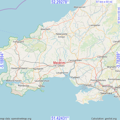
Meidrim GPS coordinates[2]
51° 51' 38.304" North, 4° 29' 8.952" West
| Map corner | latitude | longitude |
|---|---|---|
| Upper-left | 52.29278°, | -5.18894° |
| Center: | 51.86064°, | -4.48582° |
| Lower-right: | 51.42431°, | -3.78269° |
| Map W x H: | 96.6×96.6 km | = 60×60mi |
| max Lat: | 60.39635° ⇑66.2% North |
| Meidrim: | 51.86064° |
| min Lat: | ⇓33.8% South 34.60088° |
| min Long | Meidrim | max Long |
| -7.64133° | -4.48582° | 32.95536° |
| W 7%⇐ | ⇒93% E |
Elevation
Elevation of Meidrim is 39 m = 128 ft, and this is 33.9 m = 111 ft below average elevation for this country.
| Max E: |
515 m = 1690 ft | 65.5% |
| Avg. | 72.9 m = 239 ft | |
| Meidrim | 39 m = 128 ft | |
Min E: |
-30 m = -98 ft | 34.5% |
See also: United Kingdom elevation on elevation.city.
Geographical zone
Meidrim is located in North temperate zone (between Tropic of Cancer and the Arctic Circle). Distance of this North polar circle is 1634.8 km =1015.8 mi to North.| Distance of | km | miles | from Meidrim |
|---|---|---|---|
| North Pole | 4240.7 | 2635 | to North |
| Arctic Circle | 1634.8 | 1015.8 | to North |
| Tropic Cancer | 3160.4 | 1963.8 | to South |
| Equator | 5766.4 | 3583.1 | to South |


Nearby cities:
15 places around Meidrim: (largest is in red/bold)
• Abergwili
14.9 km =9.3 mi,  87°
87°
• Abernant
5.3 km =3.3 mi,  64°
64°
• Carmarthen
12.4 km =7.7 mi, 92°
• Ferryside
13.1 km =8.1 mi,  142°
142°
• Glandwr
12.6 km =7.8 mi,  306°
306°
• Laugharne
10.1 km =6.3 mi,  170°
170°
• Llanboidy
7.6 km =4.7 mi,  285°
285°
• Llanddowror
7.3 km =4.5 mi,  205°
205°
• Llangain
10.6 km =6.6 mi,  116°
116°
• Llangynog
6.8 km =4.2 mi,  130°
130°
• Llansteffan
11.8 km =7.3 mi,  146°
146°
• Llanwinio
6.2 km =3.9 mi,  330°
330°
• Saint Clears
4.6 km =2.9 mi,  190°
190°
• Trelech
9.4 km =5.8 mi,  354°
354°
• Whitland
10 km =6.2 mi,  242°
242°
Sources, notices
• [Note1] Compared only with cities in United Kingdom existing in our database
• [Src1] Map data: © OpenStreetMap contributors (CC-BY-SA)
• [Src2] Other city data from geonames.org with taken over terms of usage.
• [Src3] Geographical zone / Annual Mean Temperature by Robert A. Rohde @ Wikipedia
