Leyburn geodata
Leyburn (England) is a populated place; located in United Kingdom in Europe/London (GMT+1) time zone. With population of 2,183 people, there are 2514 cities with bigger population in this country. Compared to other cities in United Kingdom, 80.8% of cities are located further ↓South; 51.5% of cities are located further →East and 96.4% of cities have lower elevation than Leyburn. Note1
Administrative division(s):
- Level 1: England
- Level 2: North Yorkshire
- Level 3: Richmondshire District
- Level 4: Leyburn


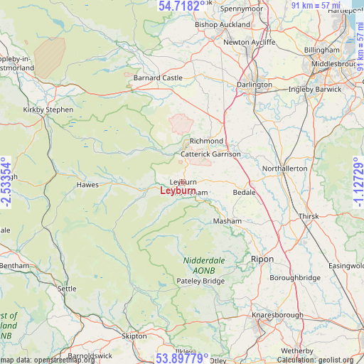
Leyburn GPS coordinates[2]
54° 18' 36.144" North, 1° 49' 49.476" West
| Map corner | latitude | longitude |
|---|---|---|
| Upper-left | 54.7182°, | -2.53354° |
| Center: | 54.31004°, | -1.83041° |
| Lower-right: | 53.89779°, | -1.12729° |
| Map W x H: | 91.2×91.2 km | = 56.7×56.7mi |
| max Lat: | 60.39635° ⇑19.2% North |
| Leyburn: | 54.31004° |
| min Lat: | ⇓80.8% South 34.60088° |
| min Long | Leyburn | max Long |
| -7.64133° | -1.83041° | 32.95536° |
| W 48.5%⇐ | ⇒51.5% E |
Elevation
Elevation of Leyburn is 199 m = 653 ft, and this is 126.1 m = 414 ft above average elevation for this country.
| Max E: |
515 m = 1690 ft | 3.6% |
| Leyburn | 199 m 653 ft | |
| Avg. | 72.9 m = 239 ft | |
Min E: |
-30 m = -98 ft | 96.4% |
See also: United Kingdom elevation on elevation.city.
Geographical zone
Leyburn is located in North temperate zone (between Tropic of Cancer and the Arctic Circle). Distance of this North polar circle is 1362.5 km =846.6 mi to North.| Distance of | km | miles | from Leyburn |
|---|---|---|---|
| North Pole | 3968.4 | 2465.8 | to North |
| Arctic Circle | 1362.5 | 846.6 | to North |
| Tropic Cancer | 3432.8 | 2133 | to South |
| Equator | 6038.7 | 3752.3 | to South |


Nearby cities:
15 places around Leyburn: (largest is in red/bold)
• Barningham
20 km =12.4 mi,  352°
352°
• Bedale
15.7 km =9.8 mi,  98°
98°
• Brignall
22 km =13.7 mi, 350°
• Catterick
14.7 km =9.1 mi,  60°
60°
• Catterick Garrison
10.3 km =6.4 mi,  43°
43°
• Hutton Magna
22.3 km =13.9 mi,  4°
4°
• Kirkby Malzeard
20.1 km =12.5 mi,  143°
143°
• Masham
14.9 km =9.3 mi,  130°
130°
• Melsonby
20.1 km =12.5 mi,  25°
25°
• Middleham
3 km =1.9 mi,  151°
151°
• Middleton Tyas
19.2 km =11.9 mi, 37°
• North Cowton
21.9 km =13.6 mi,  52°
52°
• Reeth
11.4 km =7.1 mi,  319°
319°
• Richmond
12.1 km =7.5 mi, 30°
• Scorton
17.2 km =10.7 mi, 55°
Sources, notices
• [Note1] Compared only with cities in United Kingdom existing in our database
• [Src1] Map data: © OpenStreetMap contributors (CC-BY-SA)
• [Src2] Other city data from geonames.org with taken over terms of usage.
• [Src3] Geographical zone / Annual Mean Temperature by Robert A. Rohde @ Wikipedia
