Leeds geodata
Leeds (England) is a seat of a second-order administrative division; located in United Kingdom in Europe/London (GMT+1) time zone. With population of 455,123 people, there are 9 cities with bigger population in this country. Compared to other cities in United Kingdom, 75.6% of cities are located further ↓South; 54.4% of cities are located further ←West and 57.5% of cities have higher elevation than Leeds. Note1


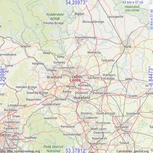
Leeds GPS coordinates[2]
53° 47' 47.328" North, 1° 32' 52.26" West
| Map corner | latitude | longitude |
|---|---|---|
| Upper-left | 54.20973°, | -2.25098° |
| Center: | 53.79648°, | -1.54785° |
| Lower-right: | 53.37912°, | -0.84473° |
| Map W x H: | 92.4×92.4 km | = 57.4×57.4mi |
| max Lat: | 60.39635° ⇑24.4% North |
| Leeds: | 53.79648° |
| min Lat: | ⇓75.6% South 34.60088° |
| min Long | Leeds | max Long |
| -7.64133° | -1.54785° | 32.95536° |
| W 54.4%⇐ | ⇒45.6% E |
Elevation
Elevation of Leeds is 50 m = 164 ft, and this is 22.9 m = 75 ft below average elevation for this country.
| Max E: |
515 m = 1690 ft | 57.5% |
| Avg. | 72.9 m = 239 ft | |
| Leeds | 50 m = 164 ft | |
Min E: |
-30 m = -98 ft | 42.5% |
See also: Leeds elevation on elevation.city.
Geographical zone
Leeds is located in North temperate zone (between Tropic of Cancer and the Arctic Circle). Distance of this North polar circle is 1419.6 km =882.1 mi to North.| Distance of | km | miles | from Leeds |
|---|---|---|---|
| North Pole | 4025.5 | 2501.3 | to North |
| Arctic Circle | 1419.6 | 882.1 | to North |
| Tropic Cancer | 3375.7 | 2097.6 | to South |
| Equator | 5981.6 | 3716.8 | to South |


Nearby cities:
15 places around Leeds: (largest is in red/bold)
• Bramhope
10.8 km =6.7 mi,  335°
335°
• Chapel Allerton
3.7 km =2.3 mi,  9°
9°
• Drighlington
8.9 km =5.5 mi,  239°
239°
• Gildersome
6.7 km =4.2 mi,  234°
234°
• Holbeck
1.9 km =1.2 mi,  222°
222°
• Horsforth
7.8 km =4.8 mi,  311°
311°
• Kirkhamgate
10.5 km =6.5 mi,  181°
181°
• Lofthouse
8.2 km =5.1 mi,  155°
155°
• Morley
7.1 km =4.4 mi,  208°
208°
• Pudsey
7.5 km =4.7 mi,  269°
269°
• Scarcroft
10.1 km =6.3 mi,  39°
39°
• Scholes
8.4 km =5.2 mi,  69°
69°
• Shadwell
8.1 km =5 mi, 37°
• Swillington
9.1 km =5.7 mi,  109°
109°
• Thorner
10.7 km =6.6 mi,  47°
47°
Sources, notices
• [Note1] Compared only with cities in United Kingdom existing in our database
• [Src1] Map data: © OpenStreetMap contributors (CC-BY-SA)
• [Src2] Other city data from geonames.org with taken over terms of usage.
• [Src3] Geographical zone / Annual Mean Temperature by Robert A. Rohde @ Wikipedia
