Morley geodata
Morley (England) is a seat of a third-order administrative division; located in United Kingdom in Europe/London (GMT+1) time zone. With population of 57,385 people, there are 197 cities with bigger population in this country. Compared to other cities in United Kingdom, 74.6% of cities are located further ↓South; 53.3% of cities are located further ←West and 89.3% of cities have lower elevation than Morley. Note1


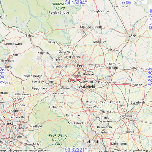
Morley GPS coordinates[2]
53° 44' 24.468" North, 1° 35' 55.572" West
| Map corner | latitude | longitude |
|---|---|---|
| Upper-left | 54.15394°, | -2.3019° |
| Center: | 53.74013°, | -1.59877° |
| Lower-right: | 53.32221°, | -0.89565° |
| Map W x H: | 92.5×92.5 km | = 57.5×57.5mi |
| max Lat: | 60.39635° ⇑25.4% North |
| Morley: | 53.74013° |
| min Lat: | ⇓74.6% South 34.60088° |
| min Long | Morley | max Long |
| -7.64133° | -1.59877° | 32.95536° |
| W 53.3%⇐ | ⇒46.7% E |
Elevation
Elevation of Morley is 148 m = 486 ft, and this is 75.1 m = 246 ft above average elevation for this country.
| Max E: |
515 m = 1690 ft | 10.7% |
| Morley | 148 m 486 ft | |
| Avg. | 72.9 m = 239 ft | |
Min E: |
-30 m = -98 ft | 89.3% |
See also: Morley elevation on elevation.city.
Geographical zone
Morley is located in North temperate zone (between Tropic of Cancer and the Arctic Circle). Distance of this North polar circle is 1425.8 km =886 mi to North.| Distance of | km | miles | from Morley |
|---|---|---|---|
| North Pole | 4031.7 | 2505.2 | to North |
| Arctic Circle | 1425.8 | 886 | to North |
| Tropic Cancer | 3369.4 | 2093.6 | to South |
| Equator | 5975.3 | 3712.9 | to South |


Nearby cities:
15 places around Morley: (largest is in red/bold)
• Batley
4.7 km =2.9 mi,  209°
209°
• Cleckheaton
7.7 km =4.8 mi,  256°
256°
• Dewsbury
5.8 km =3.6 mi,  199°
199°
• Drighlington
4.7 km =2.9 mi,  292°
292°
• Gildersome
3.2 km =2 mi,  317°
317°
• Heckmondwike
6.4 km =4 mi,  234°
234°
• Holbeck
5.2 km =3.2 mi,  22°
22°
• Horbury
9.2 km =5.7 mi,  163°
163°
• Kirkhamgate
5.2 km =3.2 mi,  144°
144°
• Leeds
7.1 km =4.4 mi,  28°
28°
• Liversedge
7.3 km =4.5 mi,  237°
237°
• Lofthouse
6.8 km =4.2 mi,  100°
100°
• Ossett
6.8 km =4.2 mi,  169°
169°
• Pudsey
7.4 km =4.6 mi,  326°
326°
• Wakefield
9.2 km =5.7 mi,  133°
133°
Sources, notices
• [Note1] Compared only with cities in United Kingdom existing in our database
• [Src1] Map data: © OpenStreetMap contributors (CC-BY-SA)
• [Src2] Other city data from geonames.org with taken over terms of usage.
• [Src3] Geographical zone / Annual Mean Temperature by Robert A. Rohde @ Wikipedia
