Lancaster geodata
Lancaster (England) is a populated place; located in United Kingdom in Europe/London (GMT+1) time zone. With population of 47,162 people, there are 251 cities with bigger population in this country. Compared to other cities in United Kingdom, 78.9% of cities are located further ↓South; 70.9% of cities are located further →East and 77.8% of cities have higher elevation than Lancaster. Note1


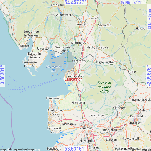
Lancaster GPS coordinates[2]
54° 2' 47.364" North, 2° 47' 59.568" West
| Map corner | latitude | longitude |
|---|---|---|
| Upper-left | 54.45727°, | -3.50301° |
| Center: | 54.04649°, | -2.79988° |
| Lower-right: | 53.63161°, | -2.09676° |
| Map W x H: | 91.8×91.8 km | = 57×57mi |
| max Lat: | 60.39635° ⇑21.1% North |
| Lancaster: | 54.04649° |
| min Lat: | ⇓78.9% South 34.60088° |
| min Long | Lancaster | max Long |
| -7.64133° | -2.79988° | 32.95536° |
| W 29.1%⇐ | ⇒70.9% E |
Elevation
Elevation of Lancaster is 23 m = 75 ft, and this is 49.9 m = 164 ft below average elevation for this country.
| Max E: |
515 m = 1690 ft | 77.8% |
| Avg. | 72.9 m = 239 ft | |
| Lancaster | 23 m = 75 ft | |
Min E: |
-30 m = -98 ft | 22.2% |
See also: Lancaster elevation on elevation.city.
Geographical zone
Lancaster is located in North temperate zone (between Tropic of Cancer and the Arctic Circle). Distance of this North polar circle is 1391.8 km =864.8 mi to North.| Distance of | km | miles | from Lancaster |
|---|---|---|---|
| North Pole | 3997.7 | 2484.1 | to North |
| Arctic Circle | 1391.8 | 864.8 | to North |
| Tropic Cancer | 3403.5 | 2114.8 | to South |
| Equator | 6009.4 | 3734.1 | to South |


Nearby cities:
15 places around Lancaster: (largest is in red/bold)
• Bay Horse
8.8 km =5.5 mi,  169°
169°
• Bolton le Sands
5.5 km =3.4 mi,  359°
359°
• Carnforth
9.7 km =6 mi,  11°
11°
• Caton
6.2 km =3.9 mi,  57°
57°
• Galgate
5.9 km =3.7 mi,  175°
175°
• Garstang
16.3 km =10.1 mi, 174°
• Grange-over-Sands
17.4 km =10.8 mi,  332°
332°
• Halton
4.5 km =2.8 mi,  37°
37°
• Heysham
6.1 km =3.8 mi,  267°
267°
• Morecambe
4.7 km =2.9 mi,  301°
301°
• Nether Kellet
7.3 km =4.5 mi,  22°
22°
• Over Kellet
9.6 km =6 mi,  27°
27°
• Overton
5.3 km =3.3 mi,  228°
228°
• Silverdale
13.4 km =8.3 mi, 355°
• Warton
11.4 km =7.1 mi, 11°
Sources, notices
• [Note1] Compared only with cities in United Kingdom existing in our database
• [Src1] Map data: © OpenStreetMap contributors (CC-BY-SA)
• [Src2] Other city data from geonames.org with taken over terms of usage.
• [Src3] Geographical zone / Annual Mean Temperature by Robert A. Rohde @ Wikipedia
