Lamlash geodata
Lamlash (Scotland) is a populated place; located in United Kingdom in Europe/London (GMT+1) time zone. With population of 1,030 people, there are 3583 cities with bigger population in this country. Compared to other cities in United Kingdom, 88.8% of cities are located further ↓South; 96.8% of cities are located further →East and 94.9% of cities have higher elevation than Lamlash. Note1


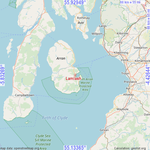
Lamlash GPS coordinates[2]
55° 32' 0.888" North, 5° 7' 46.416" West
| Map corner | latitude | longitude |
|---|---|---|
| Upper-left | 55.92949°, | -5.83269° |
| Center: | 55.53358°, | -5.12956° |
| Lower-right: | 55.13365°, | -4.42644° |
| Map W x H: | 88.5×88.5 km | = 55×55mi |
| max Lat: | 60.39635° ⇑11.2% North |
| Lamlash: | 55.53358° |
| min Lat: | ⇓88.8% South 34.60088° |
| min Long | Lamlash | max Long |
| -7.64133° | -5.12956° | 32.95536° |
| W 3.2%⇐ | ⇒96.8% E |
Elevation
Elevation of Lamlash is 8 m = 26 ft, and this is 64.9 m = 213 ft below average elevation for this country.
| Max E: |
515 m = 1690 ft | 94.9% |
| Avg. | 72.9 m = 239 ft | |
| Lamlash | 8 m = 26 ft | |
Min E: |
-30 m = -98 ft | 5.1% |
See also: United Kingdom elevation on elevation.city.
Geographical zone
Lamlash is located in North temperate zone (between Tropic of Cancer and the Arctic Circle). Distance of this North polar circle is 1226.4 km =762 mi to North.| Distance of | km | miles | from Lamlash |
|---|---|---|---|
| North Pole | 3832.3 | 2381.3 | to North |
| Arctic Circle | 1226.4 | 762 | to North |
| Tropic Cancer | 3568.8 | 2217.5 | to South |
| Equator | 6174.8 | 3836.8 | to South |


Nearby cities:
15 places around Lamlash: (largest is in red/bold)
• Ardrossan
24.1 km =15 mi,  57°
57°
• Brodick
4.8 km =3 mi,  346°
346°
• Fairlie
30.1 km =18.7 mi,  34°
34°
• Irvine
31.3 km =19.4 mi,  72°
72°
• Isle of Arran
7.4 km =4.6 mi,  315°
315°
• Isle of Cumbrae
29.3 km =18.2 mi, 26°
• Kilwinning
29.7 km =18.5 mi, 63°
• Loans
31.9 km =19.8 mi,  86°
86°
• Maidens
29.8 km =18.5 mi,  138°
138°
• Millport
27.6 km =17.1 mi, 27°
• Saltcoats
24.4 km =15.2 mi, 62°
• Stevenston
26.4 km =16.4 mi, 63°
• Troon
29.4 km =18.3 mi, 87°
• West Kilbride
24.4 km =15.2 mi,  44°
44°
• Whiting Bay
5 km =3.1 mi,  156°
156°
Sources, notices
• [Note1] Compared only with cities in United Kingdom existing in our database
• [Src1] Map data: © OpenStreetMap contributors (CC-BY-SA)
• [Src2] Other city data from geonames.org with taken over terms of usage.
• [Src3] Geographical zone / Annual Mean Temperature by Robert A. Rohde @ Wikipedia
