Kirkby Lonsdale geodata
Kirkby Lonsdale (England) is a populated place; located in United Kingdom in Europe/London (GMT+1) time zone. With population of 1,843 people, there are 2747 cities with bigger population in this country. Compared to other cities in United Kingdom, 80.2% of cities are located further ↓South; 67% of cities are located further →East and 56.6% of cities have lower elevation than Kirkby Lonsdale. Note1
Administrative division(s):
- Level 1: England
- Level 2: Cumbria
- Level 3: South Lakeland District
- Level 4: Kirkby Lonsdale


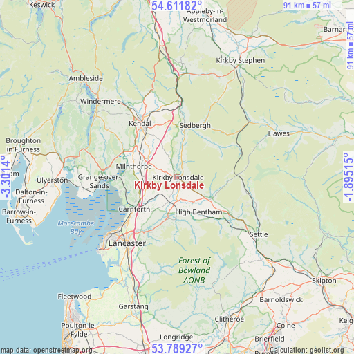
Kirkby Lonsdale GPS coordinates[2]
54° 12' 9.324" North, 2° 35' 53.772" West
| Map corner | latitude | longitude |
|---|---|---|
| Upper-left | 54.61182°, | -3.3014° |
| Center: | 54.20259°, | -2.59827° |
| Lower-right: | 53.78927°, | -1.89515° |
| Map W x H: | 91.5×91.5 km | = 56.9×56.9mi |
| max Lat: | 60.39635° ⇑19.8% North |
| Kirkby Lonsdale: | 54.20259° |
| min Lat: | ⇓80.2% South 34.60088° |
| min Long | Kirkby Lonsdale | max Long |
| -7.64133° | -2.59827° | 32.95536° |
| W 33%⇐ | ⇒67% E |
Elevation
Elevation of Kirkby Lonsdale is 71 m = 233 ft, and this is 1.9 m = 6 ft below average elevation for this country.
| Max E: |
515 m = 1690 ft | 43.4% |
| Avg. | 72.9 m = 239 ft | |
| Kirkby Lonsdale | 71 m = 233 ft | |
Min E: |
-30 m = -98 ft | 56.6% |
See also: United Kingdom elevation on elevation.city.
Geographical zone
Kirkby Lonsdale is located in North temperate zone (between Tropic of Cancer and the Arctic Circle). Distance of this North polar circle is 1374.4 km =854 mi to North.| Distance of | km | miles | from Kirkby Lonsdale |
|---|---|---|---|
| North Pole | 3980.3 | 2473.2 | to North |
| Arctic Circle | 1374.4 | 854 | to North |
| Tropic Cancer | 3420.8 | 2125.6 | to South |
| Equator | 6026.8 | 3744.9 | to South |


Nearby cities:
15 places around Kirkby Lonsdale: (largest is in red/bold)
• Arnside
15.3 km =9.5 mi,  269°
269°
• Burton in Lonsdale
7.7 km =4.8 mi,  147°
147°
• Carnforth
13.6 km =8.5 mi,  234°
234°
• Caton
16.1 km =10 mi,  209°
209°
• Heversham
12.3 km =7.6 mi,  291°
291°
• High Bentham
10.9 km =6.8 mi, 149°
• Ingleton
10 km =6.2 mi,  122°
122°
• Kendal
16.9 km =10.5 mi,  324°
324°
• Levens
14.3 km =8.9 mi,  301°
301°
• Milnthorpe
11.5 km =7.1 mi,  284°
284°
• Nether Kellet
14.9 km =9.3 mi,  224°
224°
• Over Kellet
12.4 km =7.7 mi, 224°
• Sedbergh
14 km =8.7 mi,  19°
19°
• Silverdale
14.8 km =9.2 mi,  254°
254°
• Warton
12.4 km =7.7 mi,  240°
240°
Sources, notices
• [Note1] Compared only with cities in United Kingdom existing in our database
• [Src1] Map data: © OpenStreetMap contributors (CC-BY-SA)
• [Src2] Other city data from geonames.org with taken over terms of usage.
• [Src3] Geographical zone / Annual Mean Temperature by Robert A. Rohde @ Wikipedia
