Sedbergh geodata
Sedbergh (England) is a populated place; located in United Kingdom in Europe/London (GMT+1) time zone. With population of 2,171 people, there are 2521 cities with bigger population in this country. Compared to other cities in United Kingdom, 80.8% of cities are located further ↓South; 65.7% of cities are located further →East and 85.5% of cities have lower elevation than Sedbergh. Note1
Administrative division(s):
- Level 1: England
- Level 2: Cumbria
- Level 3: South Lakeland District
- Level 4: Sedbergh


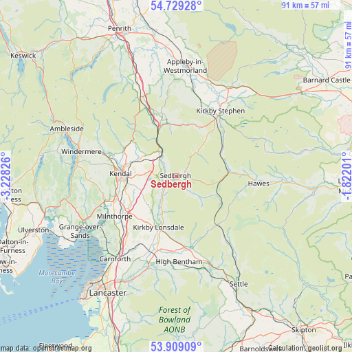
Sedbergh GPS coordinates[2]
54° 19' 16.428" North, 2° 31' 30.504" West
| Map corner | latitude | longitude |
|---|---|---|
| Upper-left | 54.72928°, | -3.22826° |
| Center: | 54.32123°, | -2.52514° |
| Lower-right: | 53.90909°, | -1.82201° |
| Map W x H: | 91.2×91.2 km | = 56.7×56.7mi |
| max Lat: | 60.39635° ⇑19.2% North |
| Sedbergh: | 54.32123° |
| min Lat: | ⇓80.8% South 34.60088° |
| min Long | Sedbergh | max Long |
| -7.64133° | -2.52514° | 32.95536° |
| W 34.3%⇐ | ⇒65.7% E |
Elevation
Elevation of Sedbergh is 134 m = 440 ft, and this is 61.1 m = 200 ft above average elevation for this country.
| Max E: |
515 m = 1690 ft | 14.5% |
| Sedbergh | 134 m 440 ft | |
| Avg. | 72.9 m = 239 ft | |
Min E: |
-30 m = -98 ft | 85.5% |
See also: United Kingdom elevation on elevation.city.
Geographical zone
Sedbergh is located in North temperate zone (between Tropic of Cancer and the Arctic Circle). Distance of this North polar circle is 1361.2 km =845.8 mi to North.| Distance of | km | miles | from Sedbergh |
|---|---|---|---|
| North Pole | 3967.1 | 2465 | to North |
| Arctic Circle | 1361.2 | 845.8 | to North |
| Tropic Cancer | 3434 | 2133.8 | to South |
| Equator | 6040 | 3753.1 | to South |


Nearby cities:
15 places around Sedbergh: (largest is in red/bold)
• Arnside
24 km =14.9 mi,  236°
236°
• Burneside
15.7 km =9.8 mi,  282°
282°
• Burton in Lonsdale
19.7 km =12.2 mi,  181°
181°
• Hawes
21.4 km =13.3 mi,  95°
95°
• Heversham
18.4 km =11.4 mi, 241°
• High Bentham
22.6 km =14 mi, 177°
• Ingleton
19 km =11.8 mi,  168°
168°
• Kendal
14.4 km =8.9 mi,  272°
272°
• Kirkby Lonsdale
14 km =8.7 mi,  199°
199°
• Kirkby Stephen
20.3 km =12.6 mi,  34°
34°
• Levens
18 km =11.2 mi,  251°
251°
• Milnthorpe
19 km =11.8 mi, 236°
• Shap
25.3 km =15.7 mi,  337°
337°
• Staveley
19.9 km =12.4 mi,  287°
287°
• Warton
24.8 km =15.4 mi,  218°
218°
Sources, notices
• [Note1] Compared only with cities in United Kingdom existing in our database
• [Src1] Map data: © OpenStreetMap contributors (CC-BY-SA)
• [Src2] Other city data from geonames.org with taken over terms of usage.
• [Src3] Geographical zone / Annual Mean Temperature by Robert A. Rohde @ Wikipedia
