Kineton geodata
Kineton (England) is a populated place; located in United Kingdom in Europe/London (GMT+1) time zone. With population of 2,014 people, there are 2620 cities with bigger population in this country. Compared to other cities in United Kingdom, 57.5% of cities are located further ↑North; 55.2% of cities are located further ←West and 67.6% of cities have lower elevation than Kineton. Note1
Administrative division(s):
- Level 1: England
- Level 2: Warwickshire
- Level 3: Stratford-on-Avon District
- Level 4: Kineton


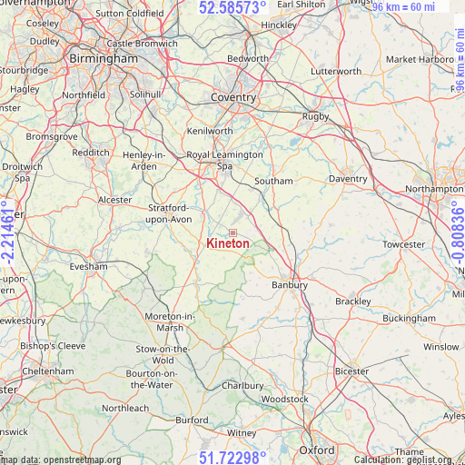
Kineton GPS coordinates[2]
52° 9' 23.22" North, 1° 30' 41.328" West
| Map corner | latitude | longitude |
|---|---|---|
| Upper-left | 52.58573°, | -2.21461° |
| Center: | 52.15645°, | -1.51148° |
| Lower-right: | 51.72298°, | -0.80836° |
| Map W x H: | 95.9×95.9 km | = 59.6×59.6mi |
| max Lat: | 60.39635° ⇑57.5% North |
| Kineton: | 52.15645° |
| min Lat: | ⇓42.5% South 34.60088° |
| min Long | Kineton | max Long |
| -7.64133° | -1.51148° | 32.95536° |
| W 55.2%⇐ | ⇒44.8% E |
Elevation
Elevation of Kineton is 91 m = 299 ft, and this is 18.1 m = 59 ft above average elevation for this country.
| Max E: |
515 m = 1690 ft | 32.4% |
| Kineton | 91 m 299 ft | |
| Avg. | 72.9 m = 239 ft | |
Min E: |
-30 m = -98 ft | 67.6% |
See also: United Kingdom elevation on elevation.city.
Geographical zone
Kineton is located in North temperate zone (between Tropic of Cancer and the Arctic Circle). Distance of this North polar circle is 1601.9 km =995.4 mi to North.| Distance of | km | miles | from Kineton |
|---|---|---|---|
| North Pole | 4207.8 | 2614.6 | to North |
| Arctic Circle | 1601.9 | 995.4 | to North |
| Tropic Cancer | 3193.3 | 1984.2 | to South |
| Equator | 5799.3 | 3603.5 | to South |


Nearby cities:
15 places around Kineton: (largest is in red/bold)
• Claydon
12.2 km =7.6 mi,  94°
94°
• Cropredy
13.9 km =8.6 mi,  108°
108°
• Eattington
6.6 km =4.1 mi,  246°
246°
• Farnborough
9.8 km =6.1 mi,  98°
98°
• Fenny Compton
8.3 km =5.2 mi,  81°
81°
• Hanwell
12.2 km =7.6 mi,  126°
126°
• Harbury
9.5 km =5.9 mi,  22°
22°
• Lower Brailes
12 km =7.5 mi,  189°
189°
• Newbold on Stour
10 km =6.2 mi,  242°
242°
• Shipston on Stour
13.3 km =8.3 mi,  216°
216°
• Southam
13.6 km =8.5 mi,  38°
38°
• Stratford-upon-Avon
13.9 km =8.6 mi,  286°
286°
• Tadmarton
14.2 km =8.8 mi,  157°
157°
• Wellesbourne
7 km =4.3 mi,  309°
309°
• Wellesbourne Mountford
7.8 km =4.8 mi,  300°
300°
Sources, notices
• [Note1] Compared only with cities in United Kingdom existing in our database
• [Src1] Map data: © OpenStreetMap contributors (CC-BY-SA)
• [Src2] Other city data from geonames.org with taken over terms of usage.
• [Src3] Geographical zone / Annual Mean Temperature by Robert A. Rohde @ Wikipedia
