Hanwell geodata
Hanwell (England) is a seat of a fourth-order administrative division; located in United Kingdom in Europe/London (GMT+1) time zone. In our database, there are 4977 cities with bigger population. Compared to other cities in United Kingdom, 59.5% of cities are located further ↑North; 58.4% of cities are located further ←West and 89% of cities have lower elevation than Hanwell. Note1
Administrative division(s):
- Level 1: England
- Level 2: Oxfordshire
- Level 3: Cherwell District
- Level 4: Hanwell


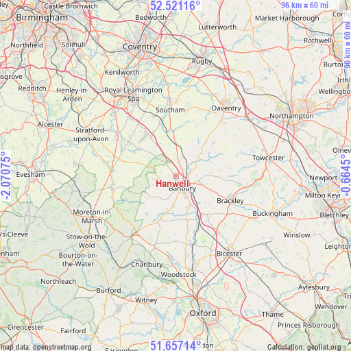
Hanwell GPS coordinates[2]
52° 5' 28.464" North, 1° 22' 3.468" West
| Map corner | latitude | longitude |
|---|---|---|
| Upper-left | 52.52116°, | -2.07075° |
| Center: | 52.09124°, | -1.36763° |
| Lower-right: | 51.65714°, | -0.6645° |
| Map W x H: | 96.1×96.1 km | = 59.7×59.7mi |
| max Lat: | 60.39635° ⇑59.5% North |
| Hanwell: | 52.09124° |
| min Lat: | ⇓40.5% South 34.60088° |
| min Long | Hanwell | max Long |
| -7.64133° | -1.36763° | 32.95536° |
| W 58.4%⇐ | ⇒41.6% E |
Elevation
Elevation of Hanwell is 147 m = 482 ft, and this is 74.1 m = 243 ft above average elevation for this country.
| Max E: |
515 m = 1690 ft | 11% |
| Hanwell | 147 m 482 ft | |
| Avg. | 72.9 m = 239 ft | |
Min E: |
-30 m = -98 ft | 89% |
See also: United Kingdom elevation on elevation.city.
Geographical zone
Hanwell is located in North temperate zone (between Tropic of Cancer and the Arctic Circle). Distance of this North polar circle is 1609.2 km =999.9 mi to North.| Distance of | km | miles | from Hanwell |
|---|---|---|---|
| North Pole | 4215.1 | 2619.1 | to North |
| Arctic Circle | 1609.2 | 999.9 | to North |
| Tropic Cancer | 3186.1 | 1979.8 | to South |
| Equator | 5792 | 3599 | to South |


Nearby cities:
15 places around Hanwell: (largest is in red/bold)
• Adderbury
9.1 km =5.7 mi,  155°
155°
• Banbury
3.6 km =2.2 mi,  150°
150°
• Barford St Michael
11.1 km =6.9 mi,  179°
179°
• Bloxham
7.9 km =4.9 mi, 182°
• Chacombe
5.8 km =3.6 mi,  90°
90°
• Chipping Warden
8.1 km =5 mi,  52°
52°
• Claydon
6.8 km =4.2 mi,  20°
20°
• Cropredy
4.5 km =2.8 mi, 49°
• Farnborough
5.7 km =3.5 mi,  358°
358°
• Fenny Compton
8.6 km =5.3 mi,  349°
349°
• Greatworth
11.8 km =7.3 mi,  97°
97°
• Kineton
12.2 km =7.6 mi,  306°
306°
• Kings Sutton
9.8 km =6.1 mi,  140°
140°
• Tadmarton
7.3 km =4.5 mi,  216°
216°
• Wardington
6.2 km =3.9 mi,  65°
65°
Sources, notices
• [Note1] Compared only with cities in United Kingdom existing in our database
• [Src1] Map data: © OpenStreetMap contributors (CC-BY-SA)
• [Src2] Other city data from geonames.org with taken over terms of usage.
• [Src3] Geographical zone / Annual Mean Temperature by Robert A. Rohde @ Wikipedia
