Kenilworth geodata
Kenilworth (England) is a populated place; located in United Kingdom in Europe/London (GMT+1) time zone. With population of 22,413 people, there are 532 cities with bigger population in this country. Compared to other cities in United Kingdom, 52.8% of cities are located further ↑North; 53.7% of cities are located further ←West and 66% of cities have lower elevation than Kenilworth. Note1
Administrative division(s):
- Level 1: England
- Level 2: Warwickshire
- Level 3: Warwick District
- Level 4: Kenilworth


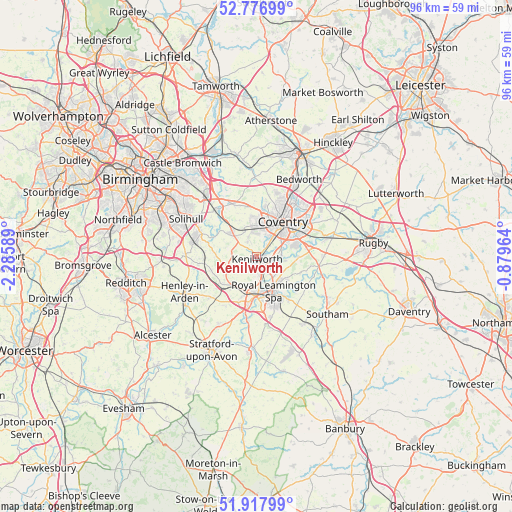
Kenilworth GPS coordinates[2]
52° 20' 58.488" North, 1° 34' 57.936" West
| Map corner | latitude | longitude |
|---|---|---|
| Upper-left | 52.77699°, | -2.28589° |
| Center: | 52.34958°, | -1.58276° |
| Lower-right: | 51.91799°, | -0.87964° |
| Map W x H: | 95.5×95.5 km | = 59.3×59.3mi |
| max Lat: | 60.39635° ⇑52.8% North |
| Kenilworth: | 52.34958° |
| min Lat: | ⇓47.2% South 34.60088° |
| min Long | Kenilworth | max Long |
| -7.64133° | -1.58276° | 32.95536° |
| W 53.7%⇐ | ⇒46.3% E |
Elevation
Elevation of Kenilworth is 88 m = 289 ft, and this is 15.1 m = 50 ft above average elevation for this country.
| Max E: |
515 m = 1690 ft | 34% |
| Kenilworth | 88 m 289 ft | |
| Avg. | 72.9 m = 239 ft | |
Min E: |
-30 m = -98 ft | 66% |
See also: United Kingdom elevation on elevation.city.
Geographical zone
Kenilworth is located in North temperate zone (between Tropic of Cancer and the Arctic Circle). Distance of this North polar circle is 1580.4 km =982 mi to North.| Distance of | km | miles | from Kenilworth |
|---|---|---|---|
| North Pole | 4186.3 | 2601.2 | to North |
| Arctic Circle | 1580.4 | 982 | to North |
| Tropic Cancer | 3214.8 | 1997.6 | to South |
| Equator | 5820.7 | 3616.8 | to South |


Nearby cities:
15 places around Kenilworth: (largest is in red/bold)
• Balsall Common
6.6 km =4.1 mi,  315°
315°
• Barston
9.5 km =5.9 mi,  306°
306°
• Berkswell
7.7 km =4.8 mi,  328°
328°
• Bubbenhall
7.8 km =4.8 mi,  91°
91°
• Coventry
7.9 km =4.9 mi,  37°
37°
• Hampton in Arden
11.7 km =7.3 mi, 316°
• Hatton
6.5 km =4 mi,  211°
211°
• Keresley
11.8 km =7.3 mi,  16°
16°
• Knowle
10.9 km =6.8 mi,  290°
290°
• Leek Wootton
3.5 km =2.2 mi,  176°
176°
• Meriden
10.6 km =6.6 mi,  337°
337°
• Royal Leamington Spa
8.3 km =5.2 mi,  149°
149°
• Ryton on Dunsmore
10.3 km =6.4 mi,  79°
79°
• Warwick
7.4 km =4.6 mi, 180°
• Wroxall
6 km =3.7 mi,  257°
257°
Sources, notices
• [Note1] Compared only with cities in United Kingdom existing in our database
• [Src1] Map data: © OpenStreetMap contributors (CC-BY-SA)
• [Src2] Other city data from geonames.org with taken over terms of usage.
• [Src3] Geographical zone / Annual Mean Temperature by Robert A. Rohde @ Wikipedia
