Coventry geodata
Coventry (England) is a seat of a second-order administrative division; located in United Kingdom in Europe/London (GMT+1) time zone. With population of 359,262 people, there are 13 cities with bigger population in this country. Compared to other cities in United Kingdom, 51.6% of cities are located further ↑North; 55.2% of cities are located further ←West and 66.5% of cities have lower elevation than Coventry. Note1


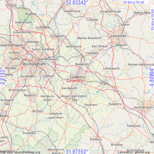
Coventry GPS coordinates[2]
52° 24' 23.616" North, 1° 30' 43.812" West
| Map corner | latitude | longitude |
|---|---|---|
| Upper-left | 52.83342°, | -2.2153° |
| Center: | 52.40656°, | -1.51217° |
| Lower-right: | 51.97553°, | -0.80904° |
| Map W x H: | 95.4×95.4 km | = 59.3×59.3mi |
| max Lat: | 60.39635° ⇑51.6% North |
| Coventry: | 52.40656° |
| min Lat: | ⇓48.4% South 34.60088° |
| min Long | Coventry | max Long |
| -7.64133° | -1.51217° | 32.95536° |
| W 55.2%⇐ | ⇒44.8% E |
Elevation
Elevation of Coventry is 89 m = 292 ft, and this is 16.1 m = 53 ft above average elevation for this country.
| Max E: |
515 m = 1690 ft | 33.5% |
| Coventry | 89 m 292 ft | |
| Avg. | 72.9 m = 239 ft | |
Min E: |
-30 m = -98 ft | 66.5% |
See also: Coventry elevation on elevation.city.
Geographical zone
Coventry is located in North temperate zone (between Tropic of Cancer and the Arctic Circle). Distance of this North polar circle is 1574.1 km =978.1 mi to North.| Distance of | km | miles | from Coventry |
|---|---|---|---|
| North Pole | 4180 | 2597.3 | to North |
| Arctic Circle | 1574.1 | 978.1 | to North |
| Tropic Cancer | 3221.1 | 2001.5 | to South |
| Equator | 5827.1 | 3620.8 | to South |


Nearby cities:
15 places around Coventry: (largest is in red/bold)
• Attleborough
12.4 km =7.7 mi,  18°
18°
• Balsall Common
9.5 km =5.9 mi,  260°
260°
• Bedworth
8.6 km =5.3 mi, 19°
• Berkswell
8.8 km =5.5 mi,  271°
271°
• Brandon
8 km =5 mi,  107°
107°
• Brinklow
10.1 km =6.3 mi,  87°
87°
• Bubbenhall
7.2 km =4.5 mi,  155°
155°
• Exhall
6.8 km =4.2 mi, 17°
• Fillongley
9.9 km =6.2 mi,  328°
328°
• Kenilworth
7.9 km =4.9 mi,  217°
217°
• Keresley
5.2 km =3.2 mi,  344°
344°
• Leek Wootton
10.9 km =6.8 mi,  204°
204°
• Meriden
9.6 km =6 mi,  291°
291°
• Ryton on Dunsmore
6.9 km =4.3 mi,  129°
129°
• Wolston
8.6 km =5.3 mi, 112°
Sources, notices
• [Note1] Compared only with cities in United Kingdom existing in our database
• [Src1] Map data: © OpenStreetMap contributors (CC-BY-SA)
• [Src2] Other city data from geonames.org with taken over terms of usage.
• [Src3] Geographical zone / Annual Mean Temperature by Robert A. Rohde @ Wikipedia
