Kemnay geodata
Kemnay (Scotland) is a populated place; located in United Kingdom in Europe/London (GMT+1) time zone. With population of 3,830 people, there are 1890 cities with bigger population in this country. Compared to other cities in United Kingdom, 97.8% of cities are located further ↓South; 63.9% of cities are located further →East and 66% of cities have lower elevation than Kemnay. Note1


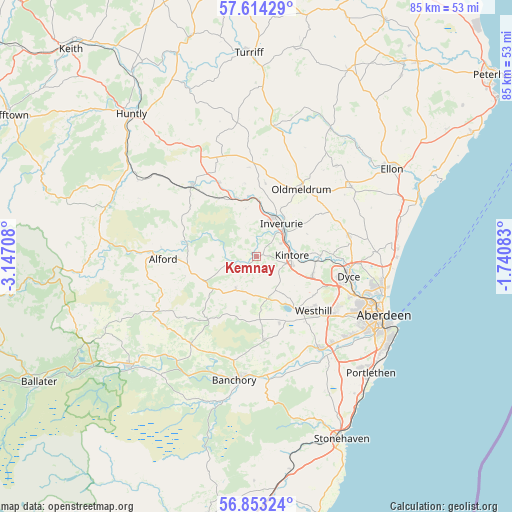
Kemnay GPS coordinates[2]
57° 14' 8.628" North, 2° 26' 38.22" West
| Map corner | latitude | longitude |
|---|---|---|
| Upper-left | 57.61429°, | -3.14708° |
| Center: | 57.23573°, | -2.44395° |
| Lower-right: | 56.85324°, | -1.74083° |
| Map W x H: | 84.6×84.6 km | = 52.6×52.6mi |
| max Lat: | 60.39635° ⇑2.2% North |
| Kemnay: | 57.23573° |
| min Lat: | ⇓97.8% South 34.60088° |
| min Long | Kemnay | max Long |
| -7.64133° | -2.44395° | 32.95536° |
| W 36.1%⇐ | ⇒63.9% E |
Elevation
Elevation of Kemnay is 88 m = 289 ft, and this is 15.1 m = 50 ft above average elevation for this country.
| Max E: |
515 m = 1690 ft | 34% |
| Kemnay | 88 m 289 ft | |
| Avg. | 72.9 m = 239 ft | |
Min E: |
-30 m = -98 ft | 66% |
See also: United Kingdom elevation on elevation.city.
Geographical zone
Kemnay is located in North temperate zone (between Tropic of Cancer and the Arctic Circle). Distance of this North polar circle is 1037.2 km =644.5 mi to North.| Distance of | km | miles | from Kemnay |
|---|---|---|---|
| North Pole | 3643 | 2263.7 | to North |
| Arctic Circle | 1037.2 | 644.5 | to North |
| Tropic Cancer | 3758.1 | 2335.2 | to South |
| Equator | 6364 | 3954.4 | to South |


Nearby cities:
15 places around Kemnay: (largest is in red/bold)
• Alford
15.6 km =9.7 mi,  268°
268°
• Blackburn
10 km =6.2 mi,  110°
110°
• Drumoak
18.3 km =11.4 mi,  161°
161°
• Dyce
16.4 km =10.2 mi,  101°
101°
• Insch
15.7 km =9.8 mi,  319°
319°
• Inverurie
6.7 km =4.2 mi,  36°
36°
• Kingseat
17.4 km =10.8 mi,  80°
80°
• Kingswells
15.8 km =9.8 mi,  123°
123°
• Kintore
5.9 km =3.7 mi,  88°
88°
• Newmacher
16 km =9.9 mi, 77°
• Oldmeldrum
13.3 km =8.3 mi,  34°
34°
• Peterculter
18.6 km =11.6 mi,  144°
144°
• Sauchen
6.4 km =4 mi,  211°
211°
• Torphins
18.1 km =11.2 mi,  216°
216°
• Westhill
13.5 km =8.4 mi,  133°
133°
Sources, notices
• [Note1] Compared only with cities in United Kingdom existing in our database
• [Src1] Map data: © OpenStreetMap contributors (CC-BY-SA)
• [Src2] Other city data from geonames.org with taken over terms of usage.
• [Src3] Geographical zone / Annual Mean Temperature by Robert A. Rohde @ Wikipedia
