Hurworth geodata
Hurworth (England) is a seat of a third-order administrative division; located in United Kingdom in Europe/London (GMT+1) time zone. In our database, there are 4977 cities with bigger population. Compared to other cities in United Kingdom, 81.9% of cities are located further ↓South; 54.7% of cities are located further ←West and 66.8% of cities have higher elevation than Hurworth. Note1


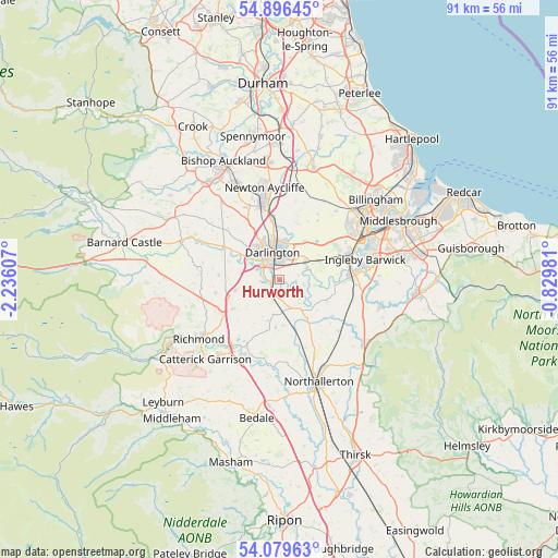
Hurworth GPS coordinates[2]
54° 29' 24.288" North, 1° 31' 58.584" West
| Map corner | latitude | longitude |
|---|---|---|
| Upper-left | 54.89645°, | -2.23607° |
| Center: | 54.49008°, | -1.53294° |
| Lower-right: | 54.07963°, | -0.82981° |
| Map W x H: | 90.8×90.8 km | = 56.4×56.4mi |
| max Lat: | 60.39635° ⇑18.1% North |
| Hurworth: | 54.49008° |
| min Lat: | ⇓81.9% South 34.60088° |
| min Long | Hurworth | max Long |
| -7.64133° | -1.53294° | 32.95536° |
| W 54.7%⇐ | ⇒45.3% E |
Elevation
Elevation of Hurworth is 37 m = 121 ft, and this is 35.9 m = 118 ft below average elevation for this country.
| Max E: |
515 m = 1690 ft | 66.8% |
| Avg. | 72.9 m = 239 ft | |
| Hurworth | 37 m = 121 ft | |
Min E: |
-30 m = -98 ft | 33.2% |
See also: United Kingdom elevation on elevation.city.
Geographical zone
Hurworth is located in North temperate zone (between Tropic of Cancer and the Arctic Circle). Distance of this North polar circle is 1342.4 km =834.1 mi to North.| Distance of | km | miles | from Hurworth |
|---|---|---|---|
| North Pole | 3948.3 | 2453.4 | to North |
| Arctic Circle | 1342.4 | 834.1 | to North |
| Tropic Cancer | 3452.8 | 2145.5 | to South |
| Equator | 6058.7 | 3764.7 | to South |


Nearby cities:
15 places around Hurworth: (largest is in red/bold)
• Bishopton
12.2 km =7.6 mi,  31°
31°
• Coatham Mundeville
10.1 km =6.3 mi,  351°
351°
• Darlington
4 km =2.5 mi,  343°
343°
• Denton
12.1 km =7.5 mi,  314°
314°
• Eaglescliffe
12.4 km =7.7 mi,  71°
71°
• East Cowton
7.4 km =4.6 mi,  177°
177°
• Elton
12.6 km =7.8 mi,  58°
58°
• High Coniscliffe
9 km =5.6 mi,  302°
302°
• Kirklevington
12.7 km =7.9 mi,  93°
93°
• Melsonby
10.6 km =6.6 mi,  259°
259°
• Middleton Tyas
8.9 km =5.5 mi,  237°
237°
• North Cowton
6.9 km =4.3 mi,  196°
196°
• Scorton
11.5 km =7.1 mi,  206°
206°
• Walworth
11.4 km =7.1 mi,  318°
318°
• Yarm
11.4 km =7.1 mi,  82°
82°
Sources, notices
• [Note1] Compared only with cities in United Kingdom existing in our database
• [Src1] Map data: © OpenStreetMap contributors (CC-BY-SA)
• [Src2] Other city data from geonames.org with taken over terms of usage.
• [Src3] Geographical zone / Annual Mean Temperature by Robert A. Rohde @ Wikipedia
