Darlington geodata
Darlington (England) is a seat of a second-order administrative division; located in United Kingdom in Europe/London (GMT+1) time zone. With population of 92,363 people, there are 107 cities with bigger population in this country. Compared to other cities in United Kingdom, 82.2% of cities are located further ↓South; 54.3% of cities are located further ←West and 64.9% of cities have higher elevation than Darlington. Note1


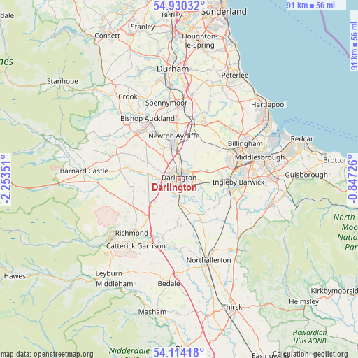
Darlington GPS coordinates[2]
54° 31' 27.444" North, 1° 33' 1.404" West
| Map corner | latitude | longitude |
|---|---|---|
| Upper-left | 54.93032°, | -2.25351° |
| Center: | 54.52429°, | -1.55039° |
| Lower-right: | 54.11418°, | -0.84726° |
| Map W x H: | 90.7×90.7 km | = 56.4×56.4mi |
| max Lat: | 60.39635° ⇑17.8% North |
| Darlington: | 54.52429° |
| min Lat: | ⇓82.2% South 34.60088° |
| min Long | Darlington | max Long |
| -7.64133° | -1.55039° | 32.95536° |
| W 54.3%⇐ | ⇒45.7% E |
Elevation
Elevation of Darlington is 40 m = 131 ft, and this is 32.9 m = 108 ft below average elevation for this country.
| Max E: |
515 m = 1690 ft | 64.9% |
| Avg. | 72.9 m = 239 ft | |
| Darlington | 40 m = 131 ft | |
Min E: |
-30 m = -98 ft | 35.1% |
See also: Darlington elevation on elevation.city.
Geographical zone
Darlington is located in North temperate zone (between Tropic of Cancer and the Arctic Circle). Distance of this North polar circle is 1338.6 km =831.8 mi to North.| Distance of | km | miles | from Darlington |
|---|---|---|---|
| North Pole | 3944.5 | 2451 | to North |
| Arctic Circle | 1338.6 | 831.8 | to North |
| Tropic Cancer | 3456.6 | 2147.8 | to South |
| Equator | 6062.5 | 3767.1 | to South |


Nearby cities:
15 places around Darlington: (largest is in red/bold)
• Bishopton
10 km =6.2 mi,  48°
48°
• Coatham Mundeville
6.2 km =3.9 mi,  356°
356°
• Denton
8.9 km =5.5 mi,  302°
302°
• East Cowton
11.3 km =7 mi,  172°
172°
• Elton
12.2 km =7.6 mi,  76°
76°
• Heighington
9.1 km =5.7 mi,  331°
331°
• High Coniscliffe
6.5 km =4 mi,  278°
278°
• Hurworth
4 km =2.5 mi,  163°
163°
• Melsonby
11 km =6.8 mi,  238°
238°
• Middleton Tyas
10.7 km =6.6 mi,  216°
216°
• Newton Aycliffe
10.6 km =6.6 mi,  352°
352°
• North Cowton
10.5 km =6.5 mi,  184°
184°
• Stillington
12.2 km =7.6 mi,  42°
42°
• Summerhouse
10.2 km =6.3 mi, 298°
• Walworth
8 km =5 mi,  306°
306°
Sources, notices
• [Note1] Compared only with cities in United Kingdom existing in our database
• [Src1] Map data: © OpenStreetMap contributors (CC-BY-SA)
• [Src2] Other city data from geonames.org with taken over terms of usage.
• [Src3] Geographical zone / Annual Mean Temperature by Robert A. Rohde @ Wikipedia
