Huddersfield geodata
Huddersfield (England) is a seat of a second-order administrative division; located in United Kingdom in Europe/London (GMT+1) time zone. With population of 149,017 people, there are 61 cities with bigger population in this country. Compared to other cities in United Kingdom, 72.8% of cities are located further ↓South; 50.8% of cities are located further →East and 67.1% of cities have lower elevation than Huddersfield. Note1


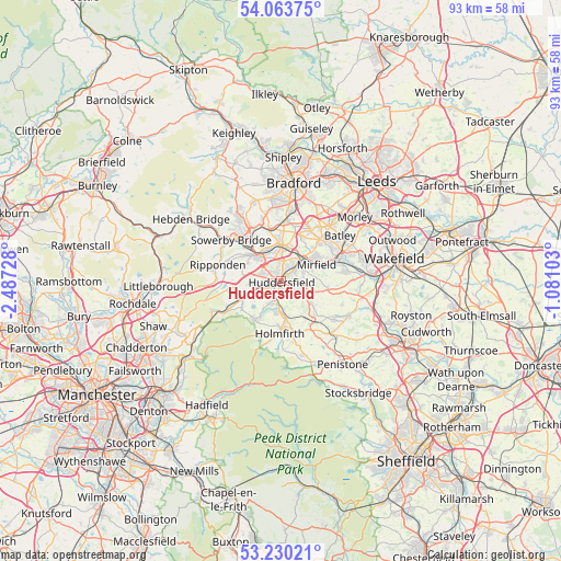
Huddersfield GPS coordinates[2]
53° 38' 56.544" North, 1° 47' 2.976" West
| Map corner | latitude | longitude |
|---|---|---|
| Upper-left | 54.06375°, | -2.48728° |
| Center: | 53.64904°, | -1.78416° |
| Lower-right: | 53.23021°, | -1.08103° |
| Map W x H: | 92.7×92.7 km | = 57.6×57.6mi |
| max Lat: | 60.39635° ⇑27.2% North |
| Huddersfield: | 53.64904° |
| min Lat: | ⇓72.8% South 34.60088° |
| min Long | Huddersfield | max Long |
| -7.64133° | -1.78416° | 32.95536° |
| W 49.2%⇐ | ⇒50.8% E |
Elevation
Elevation of Huddersfield is 90 m = 295 ft, and this is 17.1 m = 56 ft above average elevation for this country.
| Max E: |
515 m = 1690 ft | 32.9% |
| Huddersfield | 90 m 295 ft | |
| Avg. | 72.9 m = 239 ft | |
Min E: |
-30 m = -98 ft | 67.1% |
See also: Huddersfield elevation on elevation.city.
Geographical zone
Huddersfield is located in North temperate zone (between Tropic of Cancer and the Arctic Circle). Distance of this North polar circle is 1436 km =892.3 mi to North.| Distance of | km | miles | from Huddersfield |
|---|---|---|---|
| North Pole | 4041.8 | 2511.5 | to North |
| Arctic Circle | 1436 | 892.3 | to North |
| Tropic Cancer | 3359.3 | 2087.4 | to South |
| Equator | 5965.2 | 3706.6 | to South |


Nearby cities:
15 places around Huddersfield: (largest is in red/bold)
• Blackmoorfoot
6.1 km =3.8 mi,  230°
230°
• Brighouse
6 km =3.7 mi,  359°
359°
• Elland
5.4 km =3.4 mi,  318°
318°
• Halifax
8.7 km =5.4 mi,  330°
330°
• Holywell Green
6.1 km =3.8 mi,  297°
297°
• Kirkburton
6.9 km =4.3 mi,  128°
128°
• Linthwaite
5.2 km =3.2 mi,  237°
237°
• Liversedge
8.6 km =5.3 mi,  43°
43°
• Meltham
7.5 km =4.7 mi,  214°
214°
• Meltham Mills
7.2 km =4.5 mi, 210°
• Mirfield
6.4 km =4 mi,  64°
64°
• Rastrick
4.8 km =3 mi, 356°
• Shelley
8.6 km =5.3 mi, 129°
• Shepley
8.6 km =5.3 mi,  148°
148°
• Southowram
7.5 km =4.7 mi,  335°
335°
Sources, notices
• [Note1] Compared only with cities in United Kingdom existing in our database
• [Src1] Map data: © OpenStreetMap contributors (CC-BY-SA)
• [Src2] Other city data from geonames.org with taken over terms of usage.
• [Src3] Geographical zone / Annual Mean Temperature by Robert A. Rohde @ Wikipedia
