Halifax geodata
Halifax (England) is a seat of a second-order administrative division; located in United Kingdom in Europe/London (GMT+1) time zone. With population of 82,624 people, there are 123 cities with bigger population in this country. Compared to other cities in United Kingdom, 74% of cities are located further ↓South; 52% of cities are located further →East and 89.8% of cities have lower elevation than Halifax. Note1


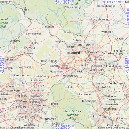
Halifax GPS coordinates[2]
53° 43' 0.012" North, 1° 51' 0" West
| Map corner | latitude | longitude |
|---|---|---|
| Upper-left | 54.13071°, | -2.55312° |
| Center: | 53.71667°, | -1.85° |
| Lower-right: | 53.29851°, | -1.14687° |
| Map W x H: | 92.5×92.5 km | = 57.5×57.5mi |
| max Lat: | 60.39635° ⇑26% North |
| Halifax: | 53.71667° |
| min Lat: | ⇓74% South 34.60088° |
| min Long | Halifax | max Long |
| -7.64133° | -1.85° | 32.95536° |
| W 48%⇐ | ⇒52% E |
Elevation
Elevation of Halifax is 150 m = 492 ft, and this is 77.1 m = 253 ft above average elevation for this country.
| Max E: |
515 m = 1690 ft | 10.2% |
| Halifax | 150 m 492 ft | |
| Avg. | 72.9 m = 239 ft | |
Min E: |
-30 m = -98 ft | 89.8% |
See also: Halifax elevation on elevation.city.
Geographical zone
Halifax is located in North temperate zone (between Tropic of Cancer and the Arctic Circle). Distance of this North polar circle is 1428.4 km =887.6 mi to North.| Distance of | km | miles | from Halifax |
|---|---|---|---|
| North Pole | 4034.3 | 2506.8 | to North |
| Arctic Circle | 1428.4 | 887.6 | to North |
| Tropic Cancer | 3366.8 | 2092 | to South |
| Equator | 5972.7 | 3711.3 | to South |


Nearby cities:
15 places around Halifax: (largest is in red/bold)
• Barkisland
6.4 km =4 mi,  224°
224°
• Brighouse
4.6 km =2.9 mi,  109°
109°
• Clayton
6 km =3.7 mi,  21°
21°
• Cleckheaton
9.1 km =5.7 mi,  84°
84°
• Cragg vale
9.9 km =6.2 mi,  263°
263°
• Elland
3.6 km =2.2 mi,  168°
168°
• Holywell Green
4.9 km =3 mi,  193°
193°
• Huddersfield
8.7 km =5.4 mi,  150°
150°
• Luddenden Foot
6.3 km =3.9 mi,  272°
272°
• Mytholmroyd
8.9 km =5.5 mi,  280°
280°
• Queensbury
5.5 km =3.4 mi,  0°
0°
• Rastrick
4.9 km =3 mi,  123°
123°
• Ripponden
7.7 km =4.8 mi,  232°
232°
• Southowram
1.4 km =0.9 mi, 122°
• Sowerby Bridge
4 km =2.5 mi, 257°
Sources, notices
• [Note1] Compared only with cities in United Kingdom existing in our database
• [Src1] Map data: © OpenStreetMap contributors (CC-BY-SA)
• [Src2] Other city data from geonames.org with taken over terms of usage.
• [Src3] Geographical zone / Annual Mean Temperature by Robert A. Rohde @ Wikipedia
