Honiton geodata
Honiton (England) is a populated place; located in United Kingdom in Europe/London (GMT+1) time zone. With population of 11,483 people, there are 947 cities with bigger population in this country. Compared to other cities in United Kingdom, 95.3% of cities are located further ↑North; 78.2% of cities are located further →East and 78.1% of cities have lower elevation than Honiton. Note1
Administrative division(s):
- Level 1: England
- Level 2: Devon
- Level 3: East Devon District
- Level 4: Honiton


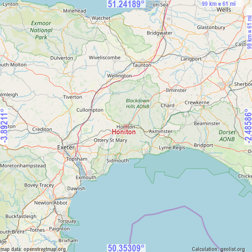
Honiton GPS coordinates[2]
50° 47' 58.56" North, 3° 11' 20.364" West
| Map corner | latitude | longitude |
|---|---|---|
| Upper-left | 51.24189°, | -3.89211° |
| Center: | 50.7996°, | -3.18899° |
| Lower-right: | 50.35309°, | -2.48586° |
| Map W x H: | 98.8×98.8 km | = 61.4×61.4mi |
| max Lat: | 60.39635° ⇑95.3% North |
| Honiton: | 50.7996° |
| min Lat: | ⇓4.7% South 34.60088° |
| min Long | Honiton | max Long |
| -7.64133° | -3.18899° | 32.95536° |
| W 21.8%⇐ | ⇒78.2% E |
Elevation
Elevation of Honiton is 113 m = 371 ft, and this is 40.1 m = 132 ft above average elevation for this country.
| Max E: |
515 m = 1690 ft | 21.9% |
| Honiton | 113 m 371 ft | |
| Avg. | 72.9 m = 239 ft | |
Min E: |
-30 m = -98 ft | 78.1% |
See also: United Kingdom elevation on elevation.city.
Geographical zone
Honiton is located in North temperate zone (between Tropic of Cancer and the Arctic Circle). Distance of this North polar circle is 1752.8 km =1089.1 mi to North.| Distance of | km | miles | from Honiton |
|---|---|---|---|
| North Pole | 4358.7 | 2708.4 | to North |
| Arctic Circle | 1752.8 | 1089.1 | to North |
| Tropic Cancer | 3042.5 | 1890.5 | to South |
| Equator | 5648.4 | 3509.8 | to South |


Nearby cities:
15 places around Honiton: (largest is in red/bold)
• Axminster
13.6 km =8.5 mi,  98°
98°
• Aylesbeare
15.2 km =9.4 mi,  233°
233°
• Colyton
10.7 km =6.6 mi,  128°
128°
• Cullompton
15.6 km =9.7 mi,  293°
293°
• Culmstock
14.2 km =8.8 mi,  333°
333°
• Dunkeswell
7.4 km =4.6 mi,  341°
341°
• Hemyock
12.8 km =8 mi,  347°
347°
• Kentisbeare
12 km =7.5 mi,  307°
307°
• Kilmington
10.8 km =6.7 mi, 102°
• Musbury
12.5 km =7.8 mi,  117°
117°
• Newton Poppleford
13.4 km =8.3 mi,  214°
214°
• Ottery St Mary
7.8 km =4.8 mi,  224°
224°
• Sidmouth
12.6 km =7.8 mi,  196°
196°
• Uffculme
15.3 km =9.5 mi,  320°
320°
• Whimple
12.3 km =7.6 mi,  252°
252°
Sources, notices
• [Note1] Compared only with cities in United Kingdom existing in our database
• [Src1] Map data: © OpenStreetMap contributors (CC-BY-SA)
• [Src2] Other city data from geonames.org with taken over terms of usage.
• [Src3] Geographical zone / Annual Mean Temperature by Robert A. Rohde @ Wikipedia
