Colyton geodata
Colyton (England) is a populated place; located in United Kingdom in Europe/London (GMT+1) time zone. With population of 2,668 people, there are 2251 cities with bigger population in this country. Compared to other cities in United Kingdom, 96% of cities are located further ↑North; 76.7% of cities are located further →East and 73.1% of cities have higher elevation than Colyton. Note1
Administrative division(s):
- Level 1: England
- Level 2: Devon
- Level 3: East Devon District
- Level 4: Colyton


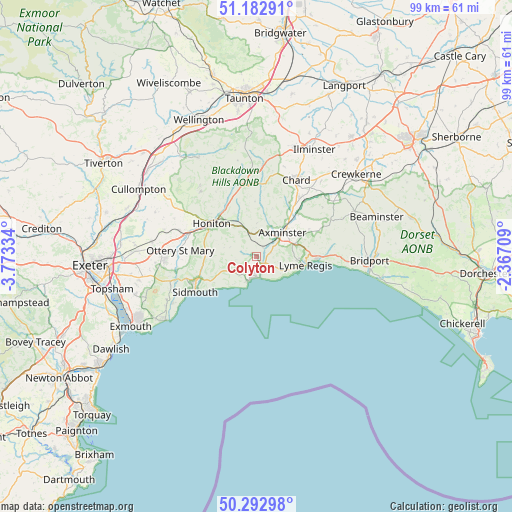
Colyton GPS coordinates[2]
50° 44' 24.216" North, 3° 4' 12.756" West
| Map corner | latitude | longitude |
|---|---|---|
| Upper-left | 51.18291°, | -3.77334° |
| Center: | 50.74006°, | -3.07021° |
| Lower-right: | 50.29298°, | -2.36709° |
| Map W x H: | 99×98.9 km | = 61.5×61.5mi |
| max Lat: | 60.39635° ⇑96% North |
| Colyton: | 50.74006° |
| min Lat: | ⇓4% South 34.60088° |
| min Long | Colyton | max Long |
| -7.64133° | -3.07021° | 32.95536° |
| W 23.3%⇐ | ⇒76.7% E |
Elevation
Elevation of Colyton is 29 m = 95 ft, and this is 43.9 m = 144 ft below average elevation for this country.
| Max E: |
515 m = 1690 ft | 73.1% |
| Avg. | 72.9 m = 239 ft | |
| Colyton | 29 m = 95 ft | |
Min E: |
-30 m = -98 ft | 26.9% |
See also: United Kingdom elevation on elevation.city.
Geographical zone
Colyton is located in North temperate zone (between Tropic of Cancer and the Arctic Circle). Distance of this North polar circle is 1759.4 km =1093.2 mi to North.| Distance of | km | miles | from Colyton |
|---|---|---|---|
| North Pole | 4365.3 | 2712.5 | to North |
| Arctic Circle | 1759.4 | 1093.2 | to North |
| Tropic Cancer | 3035.8 | 1886.4 | to South |
| Equator | 5641.8 | 3505.7 | to South |


Nearby cities:
15 places around Colyton: (largest is in red/bold)
• Axminster
6.9 km =4.3 mi,  47°
47°
• Chard
16.5 km =10.3 mi,  26°
26°
• Charmouth
11.9 km =7.4 mi,  90°
90°
• Chideock
17.7 km =11 mi, 92°
• Dunkeswell
17.4 km =10.8 mi,  321°
321°
• Honiton
10.7 km =6.6 mi,  308°
308°
• Kilmington
4.7 km =2.9 mi, 27°
• Lyme Regis
9.6 km =6 mi,  98°
98°
• Musbury
2.8 km =1.7 mi,  72°
72°
• Newton Poppleford
16.5 km =10.3 mi,  254°
254°
• Otterton
18.3 km =11.4 mi,  241°
241°
• Ottery St Mary
13.9 km =8.6 mi,  274°
274°
• Raymond's Hill
7.6 km =4.7 mi, 70°
• Sidmouth
13.1 km =8.1 mi, 245°
• Winsham
17.9 km =11.1 mi, 45°
Sources, notices
• [Note1] Compared only with cities in United Kingdom existing in our database
• [Src1] Map data: © OpenStreetMap contributors (CC-BY-SA)
• [Src2] Other city data from geonames.org with taken over terms of usage.
• [Src3] Geographical zone / Annual Mean Temperature by Robert A. Rohde @ Wikipedia
