Hinckley geodata
Hinckley (England) is a populated place; located in United Kingdom in Europe/London (GMT+0) time zone. With population of 45,249 people, there are 264 cities with bigger population in this country. Compared to other cities in United Kingdom, 51% of cities are located further ↓South; 58.2% of cities are located further ←West and 78.1% of cities have lower elevation than Hinckley. Note1
Administrative division(s):
- Level 1: England
- Level 2: Leicestershire
- Level 3: Hinckley and Bosworth District


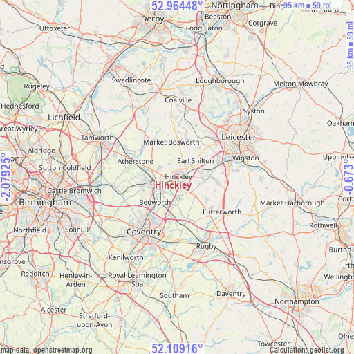
Hinckley GPS coordinates[2]
52° 32' 20.04" North, 1° 22' 34.068" West
| Map corner | latitude | longitude |
|---|---|---|
| Upper-left | 52.96448°, | -2.07925° |
| Center: | 52.5389°, | -1.37613° |
| Lower-right: | 52.10916°, | -0.673° |
| Map W x H: | 95.1×95.1 km | = 59.1×59.1mi |
| max Lat: | 60.39635° ⇑49% North |
| Hinckley: | 52.5389° |
| min Lat: | ⇓51% South 34.60088° |
| min Long | Hinckley | max Long |
| -7.64133° | -1.37613° | 32.95536° |
| W 58.2%⇐ | ⇒41.8% E |
Elevation
Elevation of Hinckley is 113 m = 371 ft, and this is 40.1 m = 132 ft above average elevation for this country.
| Max E: |
515 m = 1690 ft | 21.9% |
| Hinckley | 113 m 371 ft | |
| Avg. | 72.9 m = 239 ft | |
Min E: |
-30 m = -98 ft | 78.1% |
See also: Hinckley elevation on elevation.city.
Geographical zone
Hinckley is located in North temperate zone (between Tropic of Cancer and the Arctic Circle). Distance of this North polar circle is 1559.4 km =969 mi to North.| Distance of | km | miles | from Hinckley |
|---|---|---|---|
| North Pole | 4165.3 | 2588.2 | to North |
| Arctic Circle | 1559.4 | 969 | to North |
| Tropic Cancer | 3235.9 | 2010.7 | to South |
| Equator | 5841.8 | 3629.9 | to South |


Nearby cities:
15 places around Hinckley: (largest is in red/bold)
• Attleborough
6.1 km =3.8 mi,  241°
241°
• Bedworth
9.2 km =5.7 mi,  223°
223°
• Claybrooke Magna
8.4 km =5.2 mi,  127°
127°
• Croft
9 km =5.6 mi,  77°
77°
• Earl Shilton
5.9 km =3.7 mi,  44°
44°
• Hartshill
9.9 km =6.2 mi,  276°
276°
• Higham on the Hill
4.4 km =2.7 mi,  294°
294°
• Market Bosworth
9.6 km =6 mi,  349°
349°
• Newbold Verdon
10.3 km =6.4 mi,  12°
12°
• Nuneaton
6.3 km =3.9 mi,  253°
253°
• Sapcote
6.6 km =4.1 mi,  91°
91°
• Sharnford
5.8 km =3.6 mi,  109°
109°
• Stoke Golding
4.2 km =2.6 mi,  326°
326°
• Stoney Stanton
6.6 km =4.1 mi, 80°
• Wolvey
5.9 km =3.7 mi,  175°
175°
Sources, notices
• [Note1] Compared only with cities in United Kingdom existing in our database
• [Src1] Map data: © OpenStreetMap contributors (CC-BY-SA)
• [Src2] Other city data from geonames.org with taken over terms of usage.
• [Src3] Geographical zone / Annual Mean Temperature by Robert A. Rohde @ Wikipedia
