High Bickington geodata
High Bickington (England) is a populated place; located in United Kingdom in Europe/London (GMT+1) time zone. With population of 837 people, there are 3958 cities with bigger population in this country. Compared to other cities in United Kingdom, 91.9% of cities are located further ↑North; 87.9% of cities are located further →East and 93.2% of cities have lower elevation than High Bickington. Note1
Administrative division(s):
- Level 1: England
- Level 2: Devon
- Level 3: Torridge District
- Level 4: High Bickington


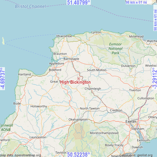
High Bickington GPS coordinates[2]
50° 58' 2.28" North, 3° 59' 39.3" West
| Map corner | latitude | longitude |
|---|---|---|
| Upper-left | 51.40799°, | -4.69737° |
| Center: | 50.9673°, | -3.99425° |
| Lower-right: | 50.52238°, | -3.29112° |
| Map W x H: | 98.5×98.5 km | = 61.2×61.2mi |
| max Lat: | 60.39635° ⇑91.9% North |
| High Bickington: | 50.9673° |
| min Lat: | ⇓8.1% South 34.60088° |
| min Long | High Bickington | max Long |
| -7.64133° | -3.99425° | 32.95536° |
| W 12.1%⇐ | ⇒87.9% E |
Elevation
Elevation of High Bickington is 167 m = 548 ft, and this is 94.1 m = 309 ft above average elevation for this country.
| Max E: |
515 m = 1690 ft | 6.8% |
| High Bickington | 167 m 548 ft | |
| Avg. | 72.9 m = 239 ft | |
Min E: |
-30 m = -98 ft | 93.2% |
See also: United Kingdom elevation on elevation.city.
Geographical zone
High Bickington is located in North temperate zone (between Tropic of Cancer and the Arctic Circle). Distance of this North polar circle is 1734.1 km =1077.5 mi to North.| Distance of | km | miles | from High Bickington |
|---|---|---|---|
| North Pole | 4340 | 2696.8 | to North |
| Arctic Circle | 1734.1 | 1077.5 | to North |
| Tropic Cancer | 3061.1 | 1902.1 | to South |
| Equator | 5667 | 3521.3 | to South |


Nearby cities:
15 places around High Bickington: (largest is in red/bold)
• Appledore
17.1 km =10.6 mi,  302°
302°
• Barnstaple
13.3 km =8.3 mi,  340°
340°
• Bideford
16 km =9.9 mi,  290°
290°
• Chawleigh
13.7 km =8.5 mi,  124°
124°
• Chulmleigh
10.6 km =6.6 mi, 124°
• Dolton
8.8 km =5.5 mi,  196°
196°
• Fremington
15.1 km =9.4 mi,  318°
318°
• Great Torrington
10.6 km =6.6 mi,  261°
261°
• Hatherleigh
17.1 km =10.6 mi, 198°
• Instow
16.1 km =10 mi,  306°
306°
• Merton
11.9 km =7.4 mi,  218°
218°
• North Molton
16.7 km =10.4 mi,  54°
54°
• South Molton
12.5 km =7.8 mi,  64°
64°
• Swimbridge
9.6 km =6 mi,  9°
9°
• Winkleigh
12.9 km =8 mi,  163°
163°
Sources, notices
• [Note1] Compared only with cities in United Kingdom existing in our database
• [Src1] Map data: © OpenStreetMap contributors (CC-BY-SA)
• [Src2] Other city data from geonames.org with taken over terms of usage.
• [Src3] Geographical zone / Annual Mean Temperature by Robert A. Rohde @ Wikipedia
