Instow geodata
Instow (England) is a populated place; located in United Kingdom in Europe/London (GMT+1) time zone. With population of 706 people, there are 4255 cities with bigger population in this country. Compared to other cities in United Kingdom, 90.2% of cities are located further ↑North; 90.3% of cities are located further →East and 82% of cities have higher elevation than Instow. Note1
Administrative division(s):
- Level 1: England
- Level 2: Devon
- Level 3: North Devon District
- Level 4: Instow


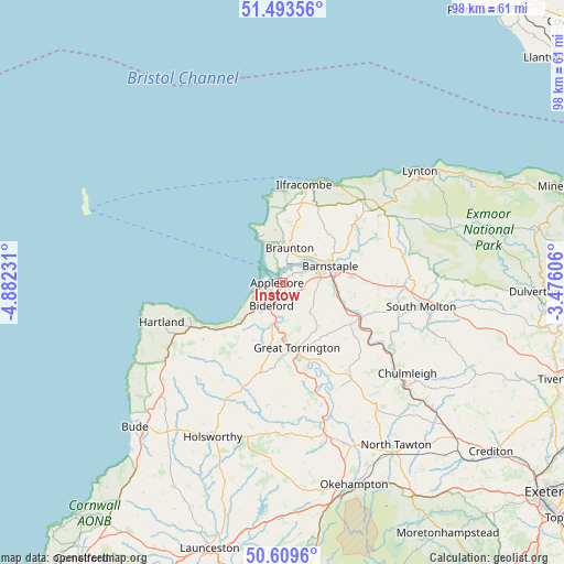
Instow GPS coordinates[2]
51° 3' 13.284" North, 4° 10' 45.048" West
| Map corner | latitude | longitude |
|---|---|---|
| Upper-left | 51.49356°, | -4.88231° |
| Center: | 51.05369°, | -4.17918° |
| Lower-right: | 50.6096°, | -3.47606° |
| Map W x H: | 98.3×98.3 km | = 61.1×61.1mi |
| max Lat: | 60.39635° ⇑90.2% North |
| Instow: | 51.05369° |
| min Lat: | ⇓9.8% South 34.60088° |
| min Long | Instow | max Long |
| -7.64133° | -4.17918° | 32.95536° |
| W 9.7%⇐ | ⇒90.3% E |
Elevation
Elevation of Instow is 19 m = 62 ft, and this is 53.9 m = 177 ft below average elevation for this country.
| Max E: |
515 m = 1690 ft | 82% |
| Avg. | 72.9 m = 239 ft | |
| Instow | 19 m = 62 ft | |
Min E: |
-30 m = -98 ft | 18% |
See also: United Kingdom elevation on elevation.city.
Geographical zone
Instow is located in North temperate zone (between Tropic of Cancer and the Arctic Circle). Distance of this North polar circle is 1724.5 km =1071.6 mi to North.| Distance of | km | miles | from Instow |
|---|---|---|---|
| North Pole | 4330.4 | 2690.8 | to North |
| Arctic Circle | 1724.5 | 1071.6 | to North |
| Tropic Cancer | 3070.7 | 1908 | to South |
| Equator | 5676.6 | 3527.3 | to South |


Nearby cities:
15 places around Instow: (largest is in red/bold)
• Appledore
1.5 km =0.9 mi,  254°
254°
• Barnstaple
9 km =5.6 mi,  70°
70°
• Berrynarbor
18.3 km =11.4 mi,  26°
26°
• Bideford
4.6 km =2.9 mi,  206°
206°
• Bratton Fleming
18.5 km =11.5 mi, 65°
• Braunton
6.2 km =3.9 mi,  11°
11°
• Croyde
9.1 km =5.7 mi,  339°
339°
• Fremington
3.5 km =2.2 mi,  59°
59°
• Great Torrington
11.5 km =7.1 mi,  167°
167°
• High Bickington
16.1 km =10 mi,  126°
126°
• Ilfracombe
17.9 km =11.1 mi, 14°
• Northam
3.5 km =2.2 mi,  229°
229°
• Swimbridge
14.6 km =9.1 mi,  90°
90°
• Woolacombe
13.4 km =8.3 mi,  351°
351°
• Woolfardisworthy
17 km =10.6 mi, 234°
Sources, notices
• [Note1] Compared only with cities in United Kingdom existing in our database
• [Src1] Map data: © OpenStreetMap contributors (CC-BY-SA)
• [Src2] Other city data from geonames.org with taken over terms of usage.
• [Src3] Geographical zone / Annual Mean Temperature by Robert A. Rohde @ Wikipedia
