Hetton-Le-Hole geodata
Hetton-Le-Hole (England) is a populated place; located in United Kingdom in Europe/London (GMT+1) time zone. With population of 13,100 people, there are 864 cities with bigger population in this country. Compared to other cities in United Kingdom, 85.1% of cities are located further ↓South; 56.5% of cities are located further ←West and 67.6% of cities have lower elevation than Hetton-Le-Hole. Note1


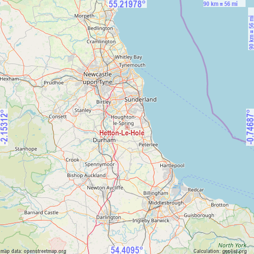
Hetton-Le-Hole GPS coordinates[2]
54° 49' 0.012" North, 1° 27' 0" West
| Map corner | latitude | longitude |
|---|---|---|
| Upper-left | 55.21978°, | -2.15312° |
| Center: | 54.81667°, | -1.45° |
| Lower-right: | 54.4095°, | -0.74687° |
| Map W x H: | 90.1×90.1 km | = 56×56mi |
| max Lat: | 60.39635° ⇑14.9% North |
| Hetton-Le-Hole: | 54.81667° |
| min Lat: | ⇓85.1% South 34.60088° |
| min Long | Hetton-Le-Hole | max Long |
| -7.64133° | -1.45° | 32.95536° |
| W 56.5%⇐ | ⇒43.5% E |
Elevation
Elevation of Hetton-Le-Hole is 91 m = 299 ft, and this is 18.1 m = 59 ft above average elevation for this country.
| Max E: |
515 m = 1690 ft | 32.4% |
| Hetton-Le-Hole | 91 m 299 ft | |
| Avg. | 72.9 m = 239 ft | |
Min E: |
-30 m = -98 ft | 67.6% |
See also: United Kingdom elevation on elevation.city.
Geographical zone
Hetton-Le-Hole is located in North temperate zone (between Tropic of Cancer and the Arctic Circle). Distance of this North polar circle is 1306.1 km =811.6 mi to North.| Distance of | km | miles | from Hetton-Le-Hole |
|---|---|---|---|
| North Pole | 3912 | 2430.8 | to North |
| Arctic Circle | 1306.1 | 811.6 | to North |
| Tropic Cancer | 3489.1 | 2168 | to South |
| Equator | 6095 | 3787.3 | to South |


Nearby cities:
15 places around Hetton-Le-Hole: (largest is in red/bold)
• Easington
6.8 km =4.2 mi,  120°
120°
• East Rainton
2.2 km =1.4 mi,  295°
295°
• Haswell
4.3 km =2.7 mi,  150°
150°
• Hawthorn
6.7 km =4.2 mi,  106°
106°
• Houghton-Le-Spring
2.8 km =1.7 mi,  340°
340°
• Murton
3.8 km =2.4 mi,  87°
87°
• Pittington
2.8 km =1.7 mi,  229°
229°
• Ryhope
8 km =5 mi,  40°
40°
• Seaham
7.1 km =4.4 mi,  69°
69°
• Sherburn
5.7 km =3.5 mi,  217°
217°
• Sherburn Hill
5.3 km =3.3 mi,  201°
201°
• Shotton
6.5 km =4 mi, 124°
• South Hetton
3.4 km =2.1 mi,  125°
125°
• Thornley
7.5 km =4.7 mi,  171°
171°
• West Rainton
3.2 km =2 mi,  270°
270°
Sources, notices
• [Note1] Compared only with cities in United Kingdom existing in our database
• [Src1] Map data: © OpenStreetMap contributors (CC-BY-SA)
• [Src2] Other city data from geonames.org with taken over terms of usage.
• [Src3] Geographical zone / Annual Mean Temperature by Robert A. Rohde @ Wikipedia
